
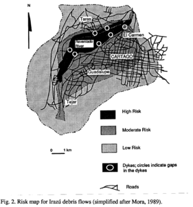
Risk map for Irazú debris flows (simplified after Mora, 1989)
Irazú, Costa Rica, 1993
Figure 2, Page 196 in: Alvarado I., G.E. (1993). Volcanology and Petrology of Irazú Volcano, Costa Rica. Christian-Albrechts-Universität, Kiel. PhD Dissertation. 288 p. (Simplified from: Mora 1993)
This hazard map is the result of scientific research and was published in academic literature.
It is presented here to serve as an example of the map type or the map-making methodology. It is NOT the official, operational map. For the current operational hazard map, please consult the proper institutional authorities.
Click on thumbnail for full-size map. We do not have copyright permission to display the full-size image. If you are the copyright holder and wish to provide copyright, please contact us at admin@volcanichazardmaps.org.
Map Set
Alvarado I., G.E. (1993). Volcanology and Petrology of Irazú Volcano, Costa Rica. Christian-Albrechts-Universität, Kiel. PhD Dissertation. 288 p. Simplified from: Mora C., S. (1993). Analysis preliminar de la vulnerabilidad economica de la ciudad de Cartago, a cause de los efectos de una avalancha que transite por el Rio Reventado, Costa Rica. Revista Geologica de America Central, 15, p. 65-80.
https://www.researchgate.net/publication/327573073_Volcanology_and_Petrology_of_Irazu_Volcano_Costa_Rica
Other Maps In Set: