
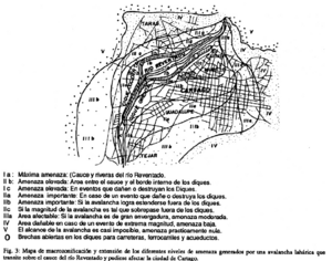
Mapa de macrozonificaión y extensión de los diferentes niveles de amenaza generados por una avalancha lahárica que transite sobre el cauce del río Reventado y pudiese afectar la ciudad de Cartago
Macrozoning map and extension of the different threat levels generated by a laharic avalanche that passes over the Reventado river bed and could affect the city of Cartago
Irazú, Costa Rica, 1993
Figure 3 in: Mora, S. (1993). Analysis preliminar de la vulnerabilidad economica de la ciudad de Cartago, a cause de los efectos de una avalancha que transite por el Rio Reventado, Costa Rica. Revista Geologica de America Central, 15, p. 65-80.
This hazard map is the result of scientific research and was published in academic literature.
It is presented here to serve as an example of the map type or the map-making methodology. It is NOT the official, operational map. For the current operational hazard map, please consult the proper institutional authorities.
Click on thumbnail for full-size map. We do not have copyright permission to display the full-size image. If you are the copyright holder and wish to provide copyright, please contact us at admin@volcanichazardmaps.org. If link seems broken, try the archived version.
Mora C., S. (1993). Analysis preliminar de la vulnerabilidad economica de la ciudad de Cartago, a cause de los efectos de una avalancha que transite por el Rio Reventado, Costa Rica. Revista Geologica de America Central, 15, p. 65-80.Map Set
https://revistas.ucr.ac.cr/index.php/geologica/article/view/13239/12514
Other Maps In Set: