
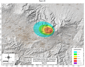
Distribución de Cenizas Evento Estromboliano Mayo
Ash Distribution Strombolian Event May
Irazú, Costa Rica, 2015
Figure 68 in: Soto, G.J. & Sjöbohm, L. (2015). Escenarios de amenaza del volcán Irazú (Costa Rica): Una aproximación preliminar. FUNDEVI, Universidad de Costa Rica, Escuela Centroamericana de Geología. 188 p. https://doi.org/10.13140/RG.2.2.22061.54240
This map was produced by an official agency, but may not be the most recent, most complete, or main operational map.
For the current operational hazard map, please consult the proper institutional authorities.
Click on thumbnail for full-size map. We do not have copyright permission to display the full-size image. If you are the copyright holder and wish to provide copyright, please contact us at admin@volcanichazardmaps.org.
Map Set
Soto, G.J. & Sjöbohm, L. (2015). Escenarios de amenaza del volcán Irazú (Costa Rica): Una aproximación preliminar. FUNDEVI, FUNDEVI, Universidad de Costa Rica, Escuela Centroamericana de Geología. 188 p.
https://www.researchgate.net/profile/Gerardo_Soto/publication/330353841_Escenarios_de_amenaza_del_volcan_Irazu_Costa_Rica_aproximacion_preliminar_informe_final_2015-12/links/5c3b8ab1458515a4c72352af/Escenarios-de-amenaza-del-volcan-Irazu-Costa-Rica-aproximacion-preliminar-informe-final-2015-12.pdf
Other Maps In Set:
- Balística volcán Irazú
- Distribución de Cenizas Evento Estromboliano Febrero
- Distribución de Cenizas Evento Estromboliano Agosto
- Distribución de Cenizas Evento Estromboliano Noviembre
- Distribución de Cenizas Evento Estromboliano Compilado
- Distribución de Cenizas Evento Vulcaniano Febrero
- Distribución de Cenizas Evento Vulcaniano Mayo
- Distribución de Cenizas Evento Vulcaniano Agosto
- Distribución de Cenizas Evento Vulcaniano Noviembre
- Distribución de Cenizas Evento Vulcaniano Compilado
- Distribución de Cenizas Evento Vulcaniano Febrero
- Distribución de Cenizas Evento Vulcaniano Mayo
- Distribución de Cenizas Evento Vulcaniano Agosto
- Distribución de Cenizas Evento Vulcaniano Noviembre
- Distribución de Cenizas Evento Vulcaniano Compilado
- Distribución de Cenizas Evento Estromboliano Febrero
- Distribución de Cenizas Evento Estromboliano Mayo
- Distribución de Cenizas Evento Estromboliano Agosto
- Distribución de Cenizas Evento Estromboliano Noviembre
- Distribución de Cenizas Evento Vulcaniano Febrero
- Distribución de Cenizas Evento Vulcaniano Mayo
- Distribución de Cenizas Evento Vulcaniano Agosto
- Distribución de Cenizas Evento Vulcaniano Noviembre
- Distribución de Cenizas Evento Vulcaniano Febrero
- Distribución de Cenizas Evento Vulcaniano Mayo
- Distribución de Cenizas Evento Vulcaniano Agosto
- Distribución de Cenizas Evento Vulcaniano Noviembre
- Area Impactada por Colapso de Columna a 5000 Metros
- Area Impactada por Colapso de Columna a 8000 Metros
- Area Impactada por Colapso de Columna a 10000 Metros
- Modelado de lavas posibles saliendo de varios sitios en el volcán Irazú