← Back to Search ResultsSíntesis de mapas de peligros volcánicos del Turrialba
Synthesis of maps of volcanic hazards of Turrialba
Turrialba, Costa Rica, 2012
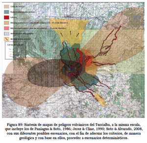
Figure 89 in: Soto, G.J. (2012). Preparación de mapas de peligros volcánicos y restricción de uso de la tierra en el volcán Turrialba. FUNDEVI, Universidad de Costa Rica, Escuela Centroamericana de Geología. 186 p.
This map was produced by an official agency, but is NOT the most recent, most complete, or main operational map.
For the current operational hazard map, please consult the proper institutional authorities.
Click on thumbnail for full-size map. We
do not have copyright permission to display the full-size image. If you are the copyright holder and wish to
provide copyright, please contact us at admin@volcanichazardmaps.org. If link seems broken, try the archived
version.Map Set
Soto, G.J. (2012). Preparación de mapas de peligros volcánicos y restricción de uso de la tierra en el volcán Turrialba. FUNDEVI, Universidad de Costa Rica, Escuela Centroamericana de Geología. 186 p.
https://rsn.ucr.ac.cr/actividad-volcanica/reportes-volcanicos/262-041112-preparacion-del-mapa-de-peligros-volcanicos-y-restriccion-de-uso-de-la-tierra-en-el-volcan-turrialba
Other Maps In Set:
- Distribución y espesor de cenizas para erupción estromboliana, periodo 1
- Distribución y espesor de cenizas para erupción estromboliana, periodo 2
- Distribución y espesor de cenizas para erupción estromboliana, periodo 3
- Distribución y espesor de cenizas para erupción estromboliana, periodo 4
- Distribución y espesor de cenizas para erupción estromboliana, combinados los 4 periodos
- Distribución y espesor de cenizas para erupción vulcaniana, periodo 1
- Distribución y espesor de cenizas para erupción vulcaniana, periodo 2
- Distribución y espesor de cenizas para erupción vulcaniana, periodo 3
- Distribución y espesor de cenizas para erupción vulcaniana, periodo 4
- Distribución y espesor de cenizas para erupción vulcaniana, combinados los 4 periodos
- Distribución y espesor de cenizas para erupción pliniana, periodo 1
- Distribución y espesor de cenizas para erupción pliniana, periodo 2
- Distribución y espesor de cenizas para erupción pliniana, periodo 3
- Distribución y espesor de cenizas para erupción pliniana, periodo 4
- Distribución y espesor de cenizas para erupción pliniana, combinados los 4 periodos
- Distribución de flujos piroclásticos originados en el cráter SW por colapso de columna estromboliana
- Distribución de flujos piroclásticos originados en el cráter SW por colapso de columna vulcaniana
- Distribución de flujos piroclásticos originados en el cráter SW por colapso de columna pliniana
- Distribución probabilística de lavas originados en diferentes puntos del volcán
- Mapas de peligros presentados por Soto & Alvarado (2008)
- Mapa de amenaza volcánica a corto plazo, áreas de máximo peligro
- Vista tridimensional del mapa de amenaza volcánica a corto plazo, áreas de máximo peligro
- Mapa de amenaza volcánica a corto plazo, áreas incluidas en el peligro intermedio a alto
- Vista tridimensional del mapa de amenaza volcánica a corto plazo, áreas incluidas en el peligro intermedio a alto
- Vista tridimensional del mapa de amenaza volcánica a corto plazo, áreas de peligro intermedio a alto y alto
- Mapa de amenaza volcánica a largo plazo, áreas límite de peligro máximo a intermedio
- Uso del suelo en los alrededores del volcán Turrialba
- Áreas de restricción sugeridas a 2 y 5 km de radio a partir del cráter SW
Map Data
Go to Global Volcanism Program page for Turrialba →
