
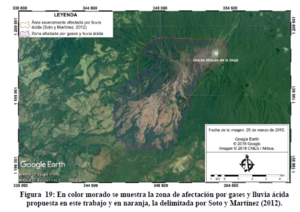
En color morado se muestra la zona de afectación por gases y lluvia ácida propuesta en este trabajo y en naranja, la delimitada por Soto y Martínez (2012)
The zone of affectation by gases and acid rain proposed in this work is shown in purple, and the one delimited by Soto and Martínez (2012) in orange.
Rincón de la Vieja, Costa Rica, 2018
Figure 19 in: Alpízar, Y. (2018). Mapa Preliminar de Peligros Volcánicos para el Volcán Rincón de la Vieja (Costa Rica): Descripción de un Escenario de Afectación por Lahares. Ciudad Universitaria Rodrigo Facio, Costa Rica. 160 p.
This hazard map is the result of scientific research and was published in academic literature.
It is presented here to serve as an example of the map type or the map-making methodology. It is NOT the official, operational map. For the current operational hazard map, please consult the proper institutional authorities.
Click on image for full-size map. If link seems broken, try the archived version.
Alpízar, Y. (2018). Mapa Preliminar de Peligros Volcánicos para el Volcán Rincón de la Vieja (Costa Rica): Descripción de un Escenario de Afectación por Lahares. Ciudad Universitaria Rodrigo Facio, Costa Rica. 160 p.Map Set
http://www.kerwa.ucr.ac.cr/handle/10669/80648
Other Maps In Set: