← Back to Search Results

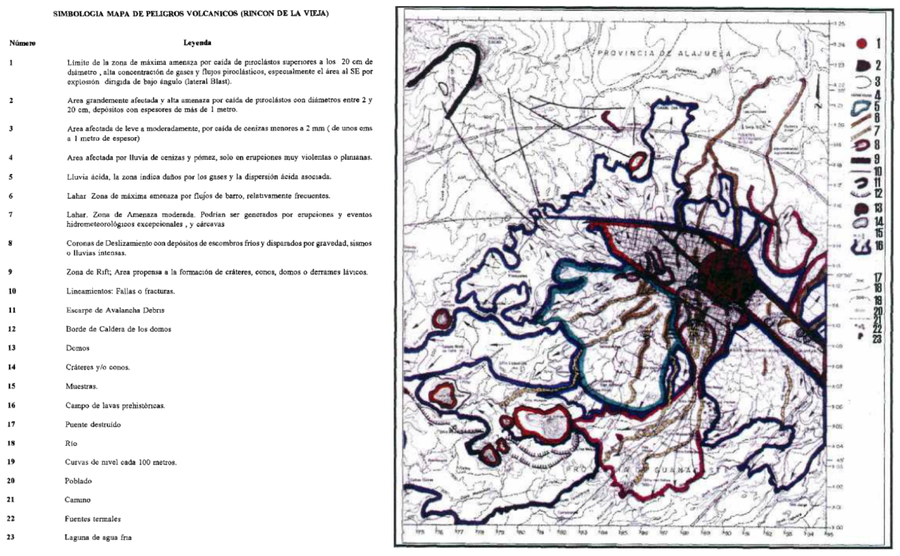
Mapa de reconocimiento de los peligros volcánicos potenciales del volcán Rincón de la Vieja, Costa Rica

Recognition map of the potential volcanic hazards of the Rincón de la Vieja volcano, Costa Rica

Rincón de la Vieja, Costa Rica, 1996

Paniagua, S., Salazar, L., Kussmaul, S., Monge, A., & Obando, L. (1996). Síntesis de la amenaza volcánica y estimación básica del riesgo del volcán Rincón de la Vieja, Cordillera de Guanacaste, Costa Rica. -64 págs. Escuela Centroamericana de Geología, Universidad de Costa Rica, San José [Informe interno].


This map was produced by an official agency, but is NOT the most recent, most complete, or main operational map. For the current operational hazard map, please consult the proper institutional authorities.


Click on image for full-size map. If link seems broken, try the archived version.

Map Data

Map ID3328
Hazard Process(es)Acid rain; Ballistics; Gas; Lahars; Lateral or directed blasts; Lava dome-related hazards; Lava flows; PDCs; Tephra fall; Vent-opening hazards
Hazard Zone PresentationHazard process-focused: Most hazard processes are separated by hazard process type on a main map panel
Temporal ScaleBackground, or long-term, map
Spatial ScaleVolcano and surrounding area
Publication FormatPoster-style map insert in hazard assessment
Zonation Method(s)Geologic history
Zonation Model(s)
Scenario(s) ConsideredSeason or weather; Size, VEI, or intensity
Hazard Zone Label(s)Hazard process name
Probability Definition(s)Qualitative relative probability (e.g. high-medium-low)
PurposeMultiple: intended for multiple purposes including general hazard awareness, planning, and crisis management
AudienceMultiple audiences (usually the public, civil authorities, and land-use planners)
Language(s)Spanish
Basemap(s)Contour lines
Basemap overlay(s)Street map
DiemsionalityPlanimetric (2D or map) view
Color SchemeCategorical/Qualitative
Go to Global Volcanism Program page for Rincón de la Vieja →