
Volcanic hazard map for future eruptions at Rincon de la Vieja volcano
Rincón de la Vieja, Costa Rica, 1996
Figure 12 in: Kempter, K. A., Benner, S. G., & Williams, S. N. (1996). Rincón de la Vieja volcano, Guanacaste province, Costa Rica: geology of the southwestern flank and hazards implications. Journal of Volcanology and Geothermal Research, 71(2-4), 109-127. https://doi.org/10.1016/0377-0273(95)00072-0
This hazard map is the result of scientific research and was published in academic literature.
It is presented here to serve as an example of the map type or the map-making methodology. It is NOT the official, operational map. For the current operational hazard map, please consult the proper institutional authorities.
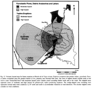
Click on thumbnail for full-size map. We do not have copyright permission to display the full-size image. If you are the copyright holder and wish to provide copyright, please contact us at admin@volcanichazardmaps.org.