
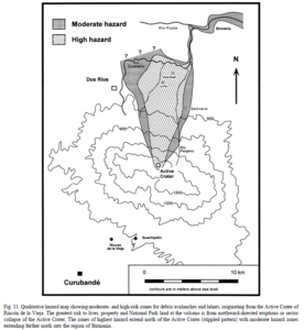
Qualitative hazard map showing moderate- and high-risk zones for debris avalanches and lahars, originating from the Active Crater of Rincón de la Vieja
Rincón de la Vieja, Costa Rica, 2000
Figure 11 in: Kempter, K. A., & Rowe, G. L. (2000). Leakage of Active Crater lake brine through the north flank at Rincón de la Vieja volcano, northwest Costa Rica, and implications for crater collapse. Journal of Volcanology and Geothermal Research, 97(1-4), 143-159. https://doi.org/10.1016/S0377-0273(99)00181-X
This hazard map is the result of scientific research and was published in academic literature.
It is presented here to serve as an example of the map type or the map-making methodology. It is NOT the official, operational map. For the current operational hazard map, please consult the proper institutional authorities.
Click on thumbnail for full-size map. We do not have copyright permission to display the full-size image. If you are the copyright holder and wish to provide copyright, please contact us at admin@volcanichazardmaps.org.