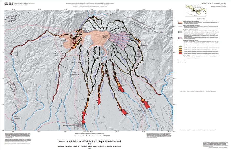
Amenaza Volcánica en el Volcán Barú, República de Panamá
Volcano Hazards of Volcán Barú, Republic of Panamá
Barú, Panama, 2008
Plate 1 (Spanish) in: Sherrod, D. R., Vallance, J. W., Espinosa, A. T., & McGeehin, J. P. (2007). Volcan Baru—eruptive history and volcano-hazards assessment. U.S. Geological Survey, Open-File Report, 2007-1401.
This map was produced by an official agency of a foreign government, but may not be the most recent, most complete, or main operational map.
For the current operational hazard map, please consult the proper institutional authorities.
Click on image for full-size map. If link seems broken, try the archived version.
Sherrod, D. R., Vallance, J. W., Espinosa, A. T., & McGeehin, J. P. (2007). Volcan Baru—eruptive history and volcano-hazards assessment. US Geological Survey, Open-File Report, 2007-1401.Map Set
https://pubs.usgs.gov/of/2007/1401/
Other Maps In Set:
Map Data
Map ID 3344 Hazard Process(es) Ash-cloud surges; Debris avalanches; Distal hazards; Lahars; PDCs; Proximal hazards; Tephra fall Hazard Zone Presentation Hazard process-focused: Most hazard processes are separated by hazard process type on a main map and series of insets Temporal Scale Background, or long-term, map Spatial Scale Volcano and surrounding area Publication Format Poster-style map insert in hazard assessment Zonation Method(s) Geologic history; Scenario modeling Zonation Model(s) Energy cone or line (Heim 1932; Sheridan 1979; Sheridan & Malin 1983); LAHARZ or modified version (such as PFZ) (Iverson et al. 1998; Schilling 1998; Schilling 2014) Scenario(s) Considered Size, VEI, or intensity; Source location or direction; Specific past eruption; Style or type Hazard Zone Label(s) Estimated value or Hazard Impact Metric; Hazard process name; Location or source name; Scenario name Probability Definition(s) Scenarios imply probability Purpose Multiple: intended for multiple purposes including general hazard awareness, planning, and crisis management Audience Multiple audiences (usually the public, civil authorities, and land-use planners) Language(s) Spanish Basemap(s) Hillshade Basemap overlay(s) Street map Diemsionality Planimetric (2D or map) view Color Scheme Dark to Light (color)