← Back to Search Results

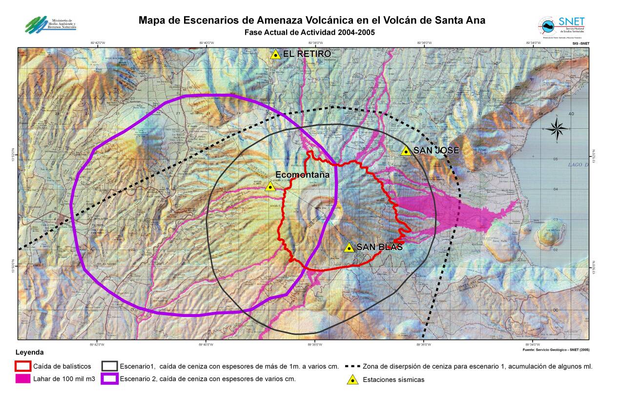
Mapa de Escenarios de Amenaza Volcánica en el Volcán de Santa Ana - Fase Actual de Actividad 2004-2005

Map of Volcanic Threat Scenarios in the Santa Ana Volcano - Current Phase of Activity 2004-2005

Santa Ana, El Salvador, 2005

Ferrés, D., Escobar, D., Pullinger, C., Vallance, J.W., & Griswold, J.P. (2005). Mapa de Escenarios de Amenaza del volcán de Santa Ana. Dirección General del Servicio Nacional de Estudios Territoriales, El Salvador (SNET), U.S. Geological Survey (USGS).


This map was produced by an official agency, but may not be the most recent, most complete, or main operational map. For the current operational hazard map, please consult the proper institutional authorities.


Click on image for full-size map. If link seems broken, try the archived version.

Map Data

Map ID3347
Hazard Process(es)Ballistics; Lahars; Tephra fall
Hazard Zone PresentationHazard process-focused: Most hazard processes are separated by hazard process type on a main map panel
Temporal ScaleCrisis, or short-term, map (hours to decades)
Spatial ScaleVolcano and surrounding area
Publication FormatMap sheet or poster
Zonation Method(s)Unknown
Zonation Model(s)
Scenario(s) ConsideredSeason or weather; Size, VEI, or intensity
Hazard Zone Label(s)Hazard process name; Scenario name
Probability Definition(s)No probability definition was discernable from the map
PurposeCrisis management and response: Intended to be used for managing, responding to, and taking action during an eruption; often includes evacuation routes, access restrictions, actions to take, etc.
AudienceMultiple audiences (usually the public, civil authorities, and land-use planners)
Language(s)Spanish
Basemap(s)Hillshade
Basemap overlay(s)Contour lines; Street map
DiemsionalityPlanimetric (2D or map) view
Color SchemeCategorical/Qualitative
Go to Global Volcanism Program page for Santa Ana →