
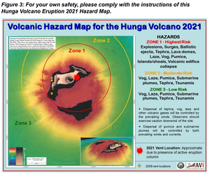
Volcanic Hazard Map for the Hunga Volcano 2021
Hunga Tonga-Hunga Ha'apai, Tonga, 2022
Figure 3 in: Tonga Geological Services. (2022). Volcanic Hazard Map for the Hunga Volcano 2021. Facebook post 2022-01-03. https://www.facebook.com/tongageologicalservice/posts/228114139479654.
This map was produced by an official agency, but may not be the most recent, most complete, or main operational map.
For the current operational hazard map, please consult the proper institutional authorities.
Click on thumbnail for full-size map. We do not have copyright permission to display the full-size image. If you are the copyright holder and wish to provide copyright, please contact us at admin@volcanichazardmaps.org. If link seems broken, try the archived version.