← Back to Search Results

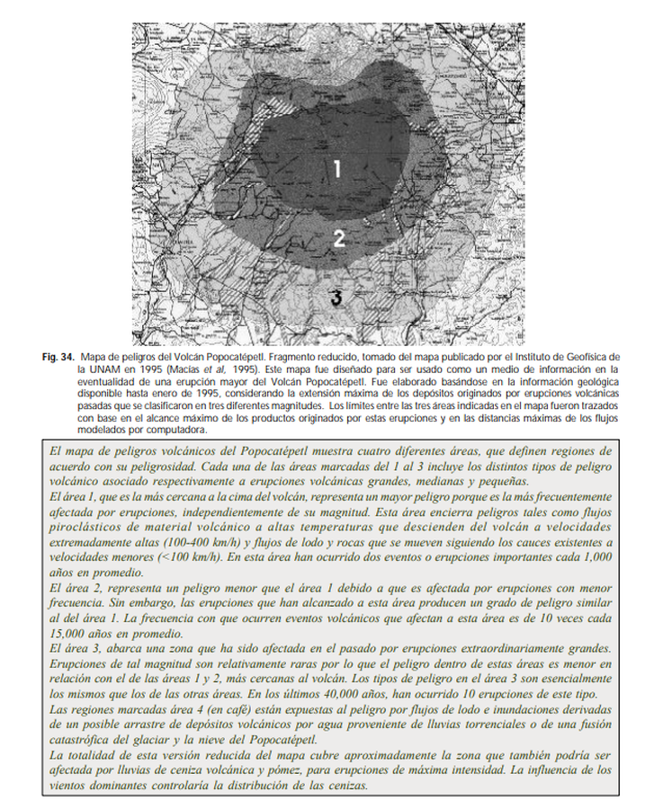
Mapa de peligros del Volcán Popocatépetl

Popocatepetl Volcano hazard map

Popocatépetl, Mexico, 2008

Figure 34 in: de la Cruz Reyna, S. (2008). Volcanes. Peligro y Riesgo Volcánico en México. Serie Fascículos. Secretaria de Gobernación. CENAPRED, México. (Simplified from: Macías et al. 1995)


This map was produced by an official agency, but is NOT the most recent, most complete, or main operational map. For the current operational hazard map, please consult the proper institutional authorities.


Click on image for full-size map. If link seems broken, try the archived version.

Map Set

de la Cruz Reyna, S. Volcanes. Peligro y Riesgo Volcánico en México. Serie Fascículos. Secretaria de Gobernación. CENAPRED, México. Simplified from: Macías J.L., Carrasco, G. Siebe, C. (1995). Zonificación de peligros volcánicos del Popocatepetl. Capitulo III Riesgos y Mapeo.
http://www.proteccioncivil.gob.mx/work/models/ProteccionCivil/Resource/363/1/images/fasciculo_volcanes.pdf

Map Data

Map ID3391
Hazard Process(es)Lahars; PDCs
Hazard Zone PresentationHazard level-focused: All or most hazards are combined by hazard level on a main map panel
Temporal ScaleBackground, or long-term, map
Spatial ScaleVolcano and surrounding area
Publication FormatFigure in a hazard assessment or mitigation plan
Zonation Method(s)Derived/simplified from another map
Zonation Model(s)
Scenario(s) ConsideredSize, VEI, or intensity
Hazard Zone Label(s)Hazard process name; Qualitative relative probability (e.g. high-medium-low)
Probability Definition(s)Recurrence interval
PurposeMultiple: intended for multiple purposes including general hazard awareness, planning, and crisis management
AudienceMultiple audiences (usually the public, civil authorities, and land-use planners)
Language(s)Spanish
Basemap(s)Contour lines
Basemap overlay(s)Street map
DiemsionalityPlanimetric (2D or map) view
Color SchemeDark to Light (greyscale)
Go to Global Volcanism Program page for Popocatépetl →