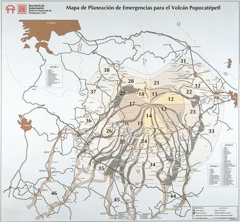
Mapa de Planeación de Emergencias para el Volcán Popocatépetl
Emergency Planning Map for the Popocatépetl Volcano
Popocatépetl, Mexico, 1995
Sistema Nacional de Protección Civil de la Secretaría de Gobernación. (1995). Mapa de planeación de emergencias del volcán Popocatépetl.
This map was produced by an official agency, but is NOT the most recent, most complete, or main operational map.
For the current operational hazard map, please consult the proper institutional authorities.
Click on image for full-size map. If link seems broken, try the archived version.
Map Data
Map ID 3393 Hazard Process(es) Lahars; Unstated or all hazards Hazard Zone Presentation Single hazard: A single hazard process is represented on a main map panel Temporal Scale Background, or long-term, map Spatial Scale Volcano and surrounding area Publication Format Unknown format Zonation Method(s) Derived/simplified from another map Zonation Model(s) Scenario(s) Considered Size, VEI, or intensity Hazard Zone Label(s) Qualitative relative probability (e.g. high-medium-low) Probability Definition(s) Qualitative relative probability (e.g. high-medium-low) Purpose Crisis management and response: Intended to be used for managing, responding to, and taking action during an eruption; often includes evacuation routes, access restrictions, actions to take, etc. Audience Civil protection authorities (emergency managers, first responders, etc.) Language(s) Spanish Basemap(s) Street map Basemap overlay(s) Diemsionality Planimetric (2D or map) view Color Scheme Dark to Light (color)