
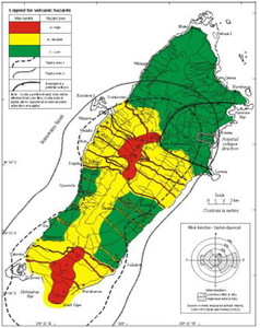
Volcanic hazard map for Taveuni Volcano (color)
Taveuni, Fiji, 2001
Figure 8 in: Cronin, S. J., & Neall, V. E. (2001). Holocene volcanic geology, volcanic hazard, and risk on Taveuni, Fiji. New Zealand Journal of Geology and Geophysics, 44(3), 417-437. https://doi.org/10.1080/00288306.2001.9514948
This hazard map is the result of scientific research and was published in academic literature.
It is presented here to serve as an example of the map type or the map-making methodology. It is NOT the official, operational map. For the current operational hazard map, please consult the proper institutional authorities.
Click on thumbnail for full-size map. We do not have copyright permission to display the full-size image. If you are the copyright holder and wish to provide copyright, please contact us at admin@volcanichazardmaps.org. If link seems broken, try the archived version.
Cronin, S. J., & Neall, V. E. (2001). Holocene volcanic geology, volcanic hazard, and risk on Taveuni, Fiji. New Zealand Journal of Geology and Geophysics, 44(3), 417-437.Map Set
https://www.tandfonline.com/doi/pdf/10.1080/00288306.2001.9514948?needAccess=true
Other Maps In Set: