
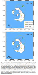
Top panel: Map of the Santorini island complex showing possible zonation of ballistic ejecta (red circle with radius 2.5 km), base surge (yellow circle with radius 6 km) and PGA values due to a Mw =5.9 shallow (3 km) earthquake accompanying the eruptive activity...Lower panel: The same for an earthquake with hypocentral depth of 5 km
Santorini, Greece, 2012
Figure 7 in: Konstantinou, K.I. & Yeh, T.Y. (2012). Stress field around the Coloumbo magma chamber, southern Aegean: Its significance for assessing volcanic and seismic hazard in Santorini. Journal of Geodynamics, 54, 13-20. https://doi.org/10.1016/j.jog.2011.09.003
This hazard map is the result of scientific research and was published in academic literature.
It is presented here to serve as an example of the map type or the map-making methodology. It is NOT the official, operational map. For the current operational hazard map, please consult the proper institutional authorities.
Click on thumbnail for full-size map. We do not have copyright permission to display the full-size image. If you are the copyright holder and wish to provide copyright, please contact us at admin@volcanichazardmaps.org. If link seems broken, try the archived version.