← Back to Search Results

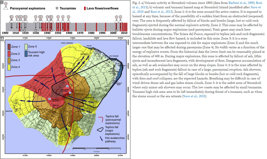
Volcanic and tsunami hazard map at Stromboli Island

Stromboli, Italy, 2014

Figure 2 in: Di Traglia, F., Nolesini, T., Intrieri, E., Mugnai, F., Leva, D., Rosi, M., & Casagli, N. (2014). Review of ten years of volcano deformations recorded by the ground-based InSAR monitoring system at Stromboli volcano: a tool to mitigate volcano flank dynamics and intense volcanic activity. Earth-Science Reviews, 139, 317-335. https://doi.org/10.1016/j.earscirev.2014.09.011


This hazard map is the result of scientific research and was published in academic literature. It is presented here to serve as an example of the map type or the map-making methodology. It is NOT the official, operational map. For the current operational hazard map, please consult the proper institutional authorities.


Click on image for full-size map. If link seems broken, try the archived version.

Map Data

Map ID3473
Hazard Process(es)Ballistics; Debris avalanches; Fire; Gas; Lateral or directed blasts; Lava flows; Tephra fall; Tsunami
Hazard Zone PresentationGrouped by process (e.g. flowage/fall hazards) on a main map panel
Temporal ScaleBackground, or long-term, map
Spatial ScaleIsland
Publication FormatFigure in a journal article
Zonation Method(s)Derived/simplified from another map
Zonation Model(s)
Scenario(s) ConsideredSize, VEI, or intensity; Source location or direction
Hazard Zone Label(s)Hazard process name; Qualitative relative probability (e.g. high-medium-low)
Probability Definition(s)Qualitative relative probability (e.g. high-medium-low)
PurposeScientific interest: Intended for scientific research and general scientific interest; usually published in academic journals
AudienceScientists (usually in scientific publication)
Language(s)English
Basemap(s)Hillshade
Basemap overlay(s)Contour lines
DiemsionalityPlanimetric (2D or map) view
Color SchemeRed to Blue
Go to Global Volcanism Program page for Stromboli →