← Back to Search Results

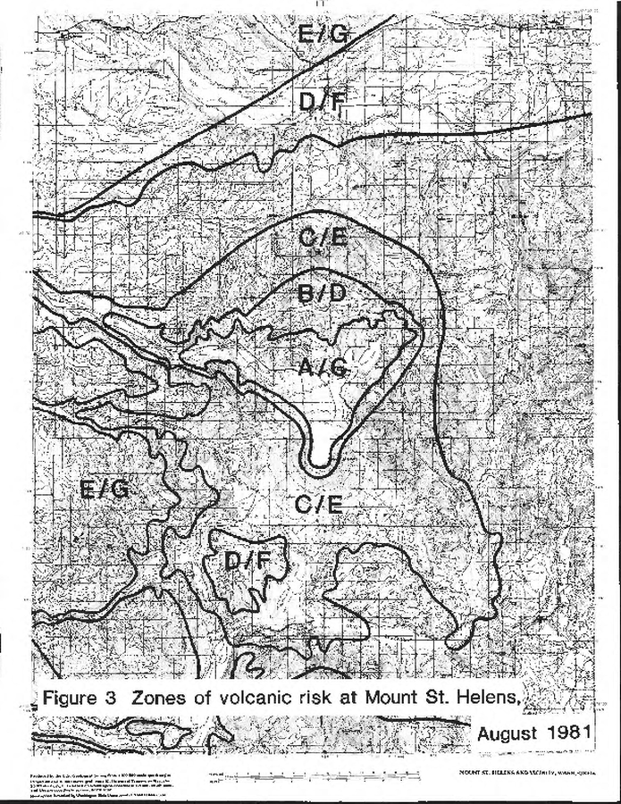
Zones of volcanic risk at Mount St. Helens August 1981

St. Helens, United States, 1982

Figure 3 in: Newhall, C.G. (1982). A method for estimating intermediate- and long-term risks from volcanic activity, with an example from Mount St. Helens, Washington. U.S. Geological Survey, Open-File Report 82-396, 59 p. doi: 10.3133/ofr82396


This map was produced by an official agency, but is NOT the most recent, most complete, or main operational map. For the current operational hazard map, please consult the proper institutional authorities.


Click on image for full-size map. If link seems broken, try the archived version.

Map Set

Newhall, C.G. (1982). A method for estimating intermediate- and long-term risks from volcanic activity, with an example from Mount St. Helens, Washington. U.S. Geological Survey, Open-File Report 82-396, 59 p. https://doi.org/10.3133/ofr82396
https://pubs.usgs.gov/of/1982/0396/report.pdf

Other Maps In Set:

Map Data

Map ID3500
Hazard Process(es)Unstated or all hazards
Hazard Zone PresentationHazard level-focused: All or most hazards are combined by hazard level on a main map panel
Temporal ScaleBackground, or long-term, map
Spatial ScaleVolcano and surrounding area
Publication FormatFigure in a hazard assessment or mitigation plan
Zonation Method(s)Event tree
Zonation Model(s)
Scenario(s) ConsideredCurrent conditions; Specific past eruption
Hazard Zone Label(s)Numeric probability
Probability Definition(s)Annual numeric probability
PurposeScientific interest: Intended for scientific research and general scientific interest; usually published in academic journals
AudienceScientists (usually in scientific publication)
Language(s)English
Basemap(s)Contour lines
Basemap overlay(s)
DiemsionalityPlanimetric (2D or map) view
Color SchemeSymbols and/or lines only
Go to Global Volcanism Program page for St. Helens →