← Back to Search Results

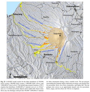
LAHARZ model results for the lahar inundation of 100,000 (dark orange), 300,000 (light orange), 1,000,000 (light yellow), and 3,000,000 m³ (dark yellow)

Soputan, Indonesia, 2012

Figure 22 in: Kushendratno, Pallister, J.S., Kristianto, Bina, F.R., McCausland, W., Carn, S., Haerani, N., Griswold, J., & Keeler, R. (2012). Recent explosive eruptions and volcano hazards at Soputan volcano—a basalt stratovolcano in north Sulawesi, Indonesia. Bulletin of volcanology, 74(7), 1581-1609. https://doi.org/10.1007/s00445-012-0620-2


This hazard map is the result of scientific research and was published in academic literature. It is presented here to serve as an example of the map type or the map-making methodology. It is NOT the official, operational map. For the current operational hazard map, please consult the proper institutional authorities.


Click on thumbnail for full-size map. We do not have copyright permission to display the full-size image. If you are the copyright holder and wish to provide copyright, please contact us at admin@volcanichazardmaps.org.

Map Data

Map ID3506
Hazard Process(es)Ballistics; Lahars; Lava flows; PDCs; Proximal hazards; Tephra fall
Hazard Zone PresentationGrouped by location (e.g. proximal/distal zones) on a main map panel
Temporal ScaleBackground, or long-term, map
Spatial ScaleVolcano and surrounding area
Publication FormatFigure in a journal article
Zonation Method(s)Scenario modeling
Zonation Model(s)LAHARZ or modified version (such as PFZ) (Iverson et al. 1998; Schilling 1998; Schilling 2014)
Scenario(s) ConsideredSize, VEI, or intensity; Source location or direction; Style or type
Hazard Zone Label(s)Location or source name; Scenario name
Probability Definition(s)Scenarios imply probability
PurposeScientific interest: Intended for scientific research and general scientific interest; usually published in academic journals
AudienceScientists (usually in scientific publication)
Language(s)English
Basemap(s)Hillshade
Basemap overlay(s)Street map
DiemsionalityPlanimetric (2D or map) view
Color SchemeRed to Yellow
Go to Global Volcanism Program page for Soputan →