← Back to Search Results

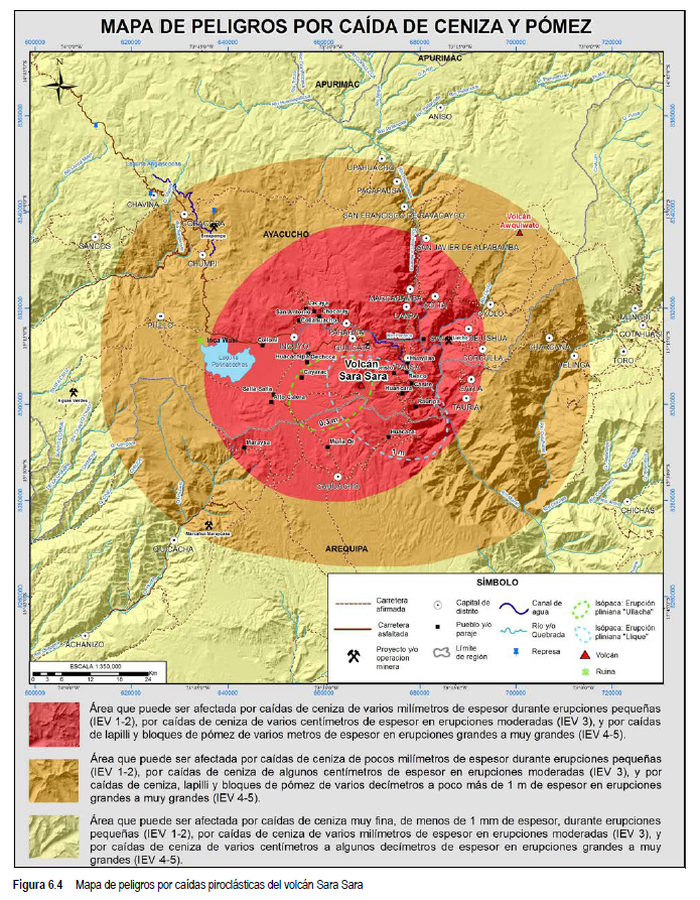
Mapas de Peligros por Caída de Ceniza y Pómez

Hazard Maps for Falling Ash and Pumice

Sara Sara, Peru, 2020

Figure 6.4 in: Rivera, M., Cueva, K., Le Pennec, J.-L., Vela, J., Samaniego, P., Manrique, N. & Soncco, Y. (2020). Geología y evaluación de peligros del volcán Sara Sara (Ayacucho). INGEMMET, Boletín, Serie C: Geodinámica e Ingeniería Geológica, 78, 154 p., 2 mapas.


This map was produced by an official agency, but may not be the most recent, most complete, or main operational map. For the current operational hazard map, please consult the proper institutional authorities.


Click on image for full-size map.

Map Set

Rivera, M., Cueva, K., Le Pennec, J.-L., Vela, J., Samaniego, P., Manrique, N. & Soncco, Y. (2020). Geología y evaluación de peligros del volcán Sara Sara (Ayacucho). INGEMMET, Boletín, Serie C: Geodinámica e Ingeniería Geológica, 78, 154 p., 2 mapas.
https://hdl.handle.net/20.500.12544/2992

Other Maps In Set:

Map Data

Map ID3700
Hazard Process(es)Tephra fall
Hazard Zone PresentationSingle hazard: A single hazard process is represented on a main map panel
Temporal ScaleBackground, or long-term, map
Spatial ScaleVolcano and surrounding area
Publication FormatFigure in a hazard assessment or mitigation plan
Zonation Method(s)Scenario modeling
Zonation Model(s)FALL3D (Costa et al. 2006; Folch et al. 2009)
Scenario(s) ConsideredSize, VEI, or intensity
Hazard Zone Label(s)Estimated value or Hazard Impact Metric
Probability Definition(s)Scenarios imply probability
PurposeMultiple: intended for multiple purposes including general hazard awareness, planning, and crisis management
AudienceMultiple audiences (usually the public, civil authorities, and land-use planners)
Language(s)Spanish
Basemap(s)Hillshade
Basemap overlay(s)Street map
DiemsionalityPlanimetric (2D or map) view
Color SchemeRed to Yellow
Go to Global Volcanism Program page for Sara Sara →