← Back to Search Results

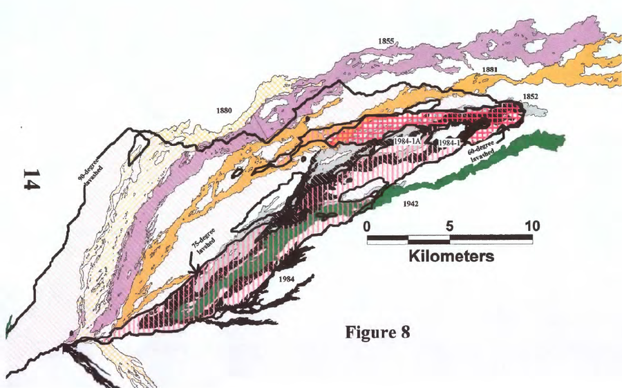
Map showing the nested 60-, 75-, and 90-degree lavasheds computed for the terminal lobes of the Mauna Loa 1984-1 and 1984-1A flows

Mauna Loa, United States, 1998

Figure 8 in: Kauahikaua, J. P., Trusdell, F. A., & Heliker, C. C. (1998). The probability of lava inundation at the proposed and existing Kulani Prison Sites. US Geological Survey, Open-File Report 98-794. 21 p. https://doi.org/10.3133/ofr98794


This map was produced by an official agency, but is NOT the most recent, most complete, or main operational map. For the current operational hazard map, please consult the proper institutional authorities.


Click on image for full-size map. If link seems broken, try the archived version.

Map Set

Kauahikaua, J. P., Trusdell, F. A., & Heliker, C. C. (1998). The probability of lava inundation at the proposed and existing Kulani Prison Sites. US Geological Survey, Open-File Report 98-794. 21 p. https://doi.org/10.3133/ofr98794
https://doi.org/10.3133/ofr98794

Other Maps In Set:

Map Data

Map ID3741
Hazard Process(es)Lava flows
Hazard Zone PresentationSingle hazard: A single hazard process is represented on a main map panel
Temporal ScaleBackground, or long-term, map
Spatial ScalePart of volcano (flank or drainage)
Publication FormatFigure in a hazard assessment or mitigation plan
Zonation Method(s)Scenario modeling
Zonation Model(s)Unnamed GIS watershed/lavashed model [Kauahikaua et al. (1998)] (Kauahikaua et al. 1998)
Scenario(s) ConsideredSource location or direction
Hazard Zone Label(s)Scenario name
Probability Definition(s)No probability definition was discernable from the map
PurposeLand-use planning: Intended to inform citing of facilities, building restrictions, resource management, and infrastructure development
AudienceLand-use planners, city planners, government officials, etc.
Language(s)English
Basemap(s)No basemap
Basemap overlay(s)
DiemsionalityPlanimetric (2D or map) view
Color SchemeSymbols and/or lines only
Go to Global Volcanism Program page for Mauna Loa →