
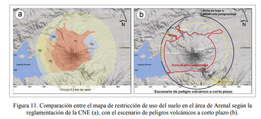
Comparación entre el mapa de restricción de uso del suelo en el área de Arenal según la reglamentación de la CNE, con el escenario de peligros volcánicos a corto plazo.
Comparison between the land use restriction map in the Arenal area according to CNE regulations, with the short-term volcanic hazard scenario.
Arenal, Costa Rica, 2005
Figure 11 in: Soto, G.J. & Sjöbohm, L. (2005). Sobre el mapeo de los peligros volcánicos del Arenal (Costa Rica) como una herramienta para la planificación del uso del suelo y la mitigación de desastres. Memoria VIII Seminario de Ingeniería Estructural y Sísmica, San José, Costa Rica, Septiembre 2005, 26 p.
This hazard map is the result of scientific research and was published in academic literature.
It is presented here to serve as an example of the map type or the map-making methodology. It is NOT the official, operational map. For the current operational hazard map, please consult the proper institutional authorities.
Click on thumbnail for full-size map. We do not have copyright permission to display the full-size image. If you are the copyright holder and wish to provide copyright, please contact us at admin@volcanichazardmaps.org. If link seems broken, try the archived version.
Soto, G.J. & Sjöbohm, L. (2005). Sobre el mapeo de los peligros volcánicos del Arenal (Costa Rica) como una herramienta para la planificación del uso del suelo y la mitigación de desastres. Memoria VIII Seminario de Ingeniería Estructural y Sísmica, San José, Costa Rica, Septiembre 2005, 26 p.Map Set
https://pages.mtu.edu/~raman/papers2/Soto&Sjobohm05Arenal.pdf
Other Maps In Set: