← Back to Search Results

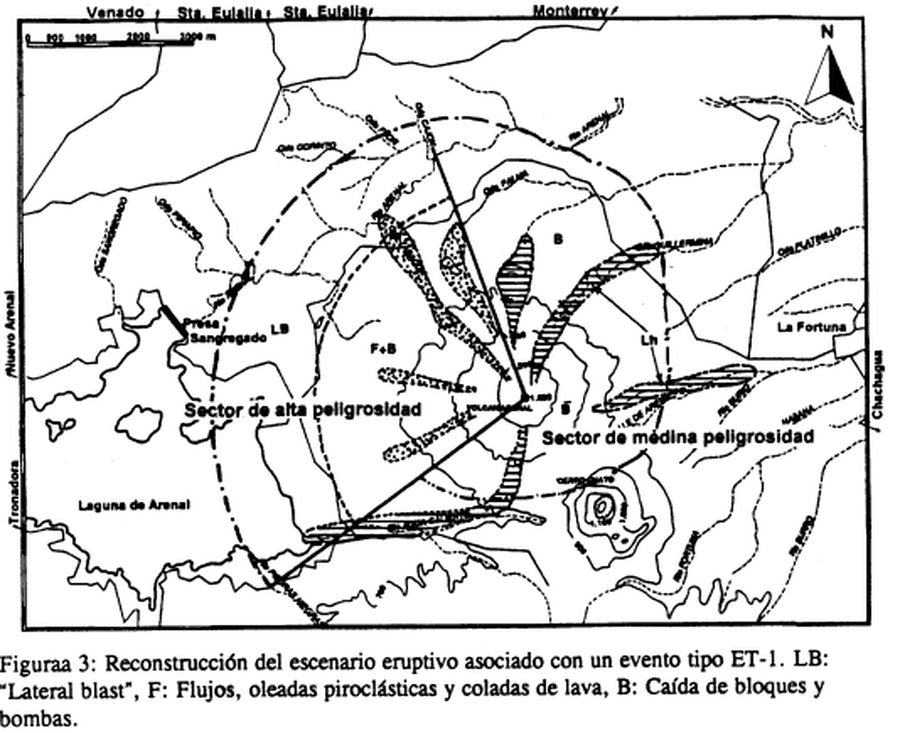
Reconstrucción del escenario eruptivo asociado con un evento tipo ET-1

Reconstruction of the eruptive scenario associated with an ET-1 type event

Arenal, Costa Rica, 1997

Figure 3 in: Alvarado, G.E., Soto, G.J., Ghigliotti, M., & Frullani, A. (1997). Peligro volcánico del Arenal. Boletín OSIVAM, 8(15-16), p. 62-82.


This map was produced by an official agency, but is NOT the most recent, most complete, or main operational map. For the current operational hazard map, please consult the proper institutional authorities.


Click on image for full-size map. If link seems broken, try the archived version.

Map Set

Alvarado, G.E., Soto, G.J., Ghigliotti, M., and Frullani, A. (1997). Peligro volcánico del Arenal. Boletín OSIVAM, 8(15-16), p. 62-82.
https://rsn.ucr.ac.cr/images/Biblioteca/Publicaciones_Periodicas/Boletines_OSIVAM/15_16_BoletinOSIVAM_08_Junio_1997.pdf

Other Maps In Set:

Map Data

Map ID3871
Hazard Process(es)Ballistics; Flowage hazards; Lateral or directed blasts; PDCs; Surges; Unstated or all hazards
Hazard Zone PresentationHazard process-focused: Most hazard processes are separated by hazard process type on a main map panel
Temporal ScaleBackground, or long-term, map
Spatial ScaleVolcano and surrounding area
Publication FormatFigure in a hazard assessment or mitigation plan
Zonation Method(s)Geologic history
Zonation Model(s)
Scenario(s) ConsideredSpecific past eruption
Hazard Zone Label(s)Hazard process name; Qualitative relative probability (e.g. high-medium-low)
Probability Definition(s)Qualitative relative probability (e.g. high-medium-low)
PurposeLand-use planning: Intended to inform citing of facilities, building restrictions, resource management, and infrastructure development
AudienceLand-use planners, city planners, government officials, etc.
Language(s)Spanish
Basemap(s)Contour lines
Basemap overlay(s)
DiemsionalityPlanimetric (2D or map) view
Color SchemeSymbols and/or lines only
Go to Global Volcanism Program page for Arenal →