← Back to Search Results

Amenaza por Flujos Piroclasticos en el Volcán Concepción

Threat due to Pyroclastic Flows in the Concepción Volcano

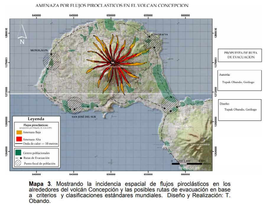
Concepción, Nicaragua, 2009

Obando, T. & Navarro, M. (2009). Propuestade Rutas de Evacuación ante peligros por Caída de Cenizas y Flujos Piroclásticos en la Isla de Ometepe (Rivas, Nicaragua). https://1library.co/document/y621ejgz-propuesta-evacuacion-peligros-caida-cenizas-piroclasticos-ometepe-nicaragua.html


This map may not be the most recent, most complete, or main operational map. For the current operational hazard map, please consult the proper institutional authorities.


Click on image for full-size map. If link seems broken, try the archived version.

Map Set

Obando, T., and Navarro, M. (2009). Propuestade Rutas de Evacuación ante peligros por Caída de Cenizas y Flujos Piroclásticos en la Isla de Ometepe (Rivas, Nicaragua). https://1library.co/document/y621ejgz-propuesta-evacuacion-peligros-caida-cenizas-piroclasticos-ometepe-nicaragua.html
https://www.monografias.com/trabajos-pdf4/rutas-evacuacion-peligros-caida-cenizas/rutas-evacuacion-peligros-caida-cenizas.pdf

Other Maps In Set:

Map Data

Map ID3877
Hazard Process(es)Ash-cloud surges; PDCs
Hazard Zone PresentationSingle hazard: A single hazard process is represented on a main map panel
Temporal ScaleBackground, or long-term, map
Spatial ScaleVolcano and surrounding area
Publication FormatFigure in a hazard assessment or mitigation plan
Zonation Method(s)Geologic history
Zonation Model(s)
Scenario(s) ConsideredNo scenarios were discernable from the map
Hazard Zone Label(s)Estimated value or Hazard Impact Metric; Qualitative relative probability (e.g. high-medium-low)
Probability Definition(s)Qualitative relative probability (e.g. high-medium-low)
PurposeCrisis management and response: Intended to be used for managing, responding to, and taking action during an eruption; often includes evacuation routes, access restrictions, actions to take, etc.
AudienceMultiple audiences (usually the public, civil authorities, and land-use planners)
Language(s)Spanish
Basemap(s)Topographic map (colored contour map)
Basemap overlay(s)
DiemsionalityPlanimetric (2D or map) view
Color SchemeRed to Yellow
Go to Global Volcanism Program page for Concepción →