← Back to Search Results

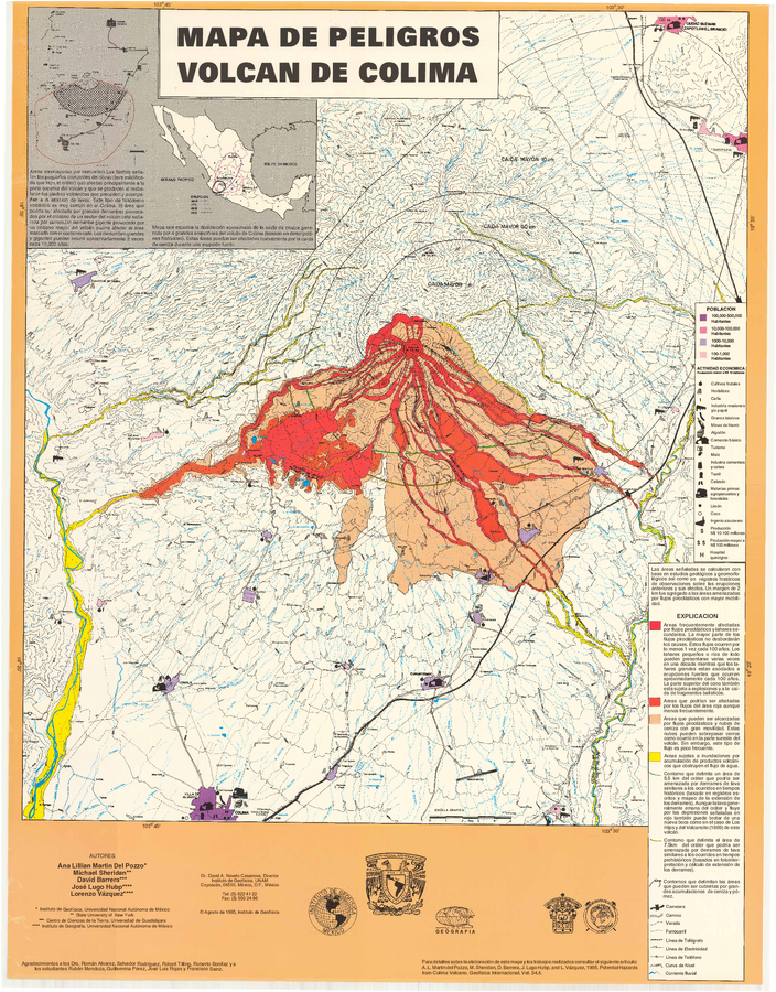
Mapa de Peligros Volcan de Colima

Colima Volcano Hazards Map

Colima, Mexico, 1995

Martin del Pozzo, A.L., Sheridan, M., Barrera, D., Lugo-Hubp, J., & Vázquez Selem, L. (1995). Mapa de Peligros Volcán de Colima. Instituto de Geofísica UNAM.


This map was produced by an official agency, but is NOT the most recent, most complete, or main operational map. For the current operational hazard map, please consult the proper institutional authorities.

If link seems broken, try the archived version.

Map Set

Martin Del Pozzo, A. L., Sheridan, M., Barrera, D., Lugo Hubp, J., & Vázquez Selem, L. (1995). Potential hazards from Colima volcano, Mexico. Geofisica Internacional, 34(4), 363–376. Recuperado a partir de http://132.248.182.214/index.php/RGI/article/view/1422
http://132.248.182.214/index.php/RGI/article/view/1422

Other Maps In Set:

Map Data

Map ID3888
Hazard Process(es)Ash-cloud surges; Ballistics; Debris avalanches; Floods or jokulhaups; Lahars; Lava flows; PDCs; Tephra fall
Hazard Zone PresentationHazard process-focused: Most hazard processes are separated by hazard process type on a main map panel
Temporal ScaleBackground, or long-term, map
Spatial ScaleVolcano and surrounding area
Publication FormatMap sheet or poster
Zonation Method(s)Geologic history
Zonation Model(s)
Scenario(s) ConsideredSize, VEI, or intensity; Specific past eruption; Style or type
Hazard Zone Label(s)Estimated value or Hazard Impact Metric; Hazard process name
Probability Definition(s)Qualitative relative probability (e.g. high-medium-low); Recurrence interval
PurposeMultiple: intended for multiple purposes including general hazard awareness, planning, and crisis management
AudienceMultiple audiences (usually the public, civil authorities, and land-use planners)
Language(s)Spanish
Basemap(s)Contour lines
Basemap overlay(s)Land-cover map; Population map; Street map
DiemsionalityPlanimetric (2D or map) view
Color SchemeRed to Yellow
Go to Global Volcanism Program page for Colima →