← Back to Search Results

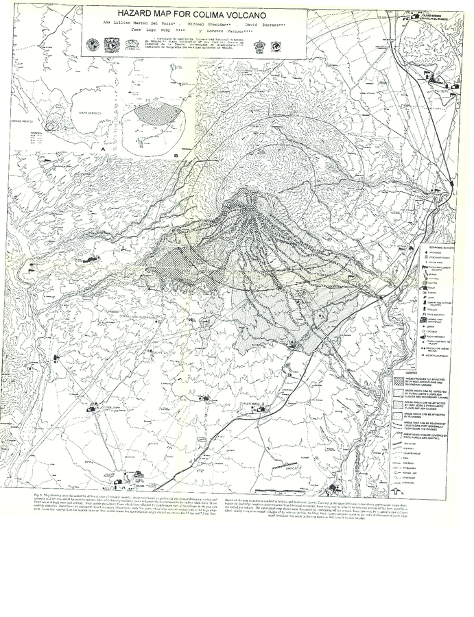
Hazard Map for Colima Volcano

Colima, Mexico, 1995

Figure 6 in: Martin Del Pozzo, A. L., Sheridan, M., Barrera, D., Lugo Hubp, J., & Vázquez Selem, L. (1995). Potential hazards from Colima volcano, Mexico. Geofisica Internacional, 34(4), 363–376. Recuperado a partir de http://132.248.182.214/index.php/RGI/article/view/1422 (Modified version of: Martin Del Pozzo et al. 1995)


This map was produced by an official agency, but is NOT the most recent, most complete, or main operational map. For the current operational hazard map, please consult the proper institutional authorities.


Click on thumbnail for full-size map. We do not have copyright permission to display the full-size image. If you are the copyright holder and wish to provide copyright, please contact us at admin@volcanichazardmaps.org. If link seems broken, try the archived version.

Map Set

Martin Del Pozzo, A. L., Sheridan, M., Barrera, D., Lugo Hubp, J., & Vázquez Selem, L. (1995). Potential hazards from Colima volcano, Mexico. Geofisica Internacional, 34(4), 363–376. Recuperado a partir de http://132.248.182.214/index.php/RGI/article/view/1422
http://132.248.182.214/index.php/RGI/article/view/1422

Other Maps In Set:

Map Data

Map ID3889
Hazard Process(es)Ash-cloud surges; Debris avalanches; Floods or jokulhaups; Lahars; Lava flows; PDCs; Tephra fall
Hazard Zone PresentationHazard process-focused: Most hazard processes are separated by hazard process type on a main map panel
Temporal ScaleBackground, or long-term, map
Spatial ScaleVolcano and surrounding area
Publication FormatFigure in a hazard assessment or mitigation plan
Zonation Method(s)Derived/simplified from another map
Zonation Model(s)
Scenario(s) ConsideredSize, VEI, or intensity; Specific past eruption; Style or type
Hazard Zone Label(s)Estimated value or Hazard Impact Metric; Hazard process name
Probability Definition(s)Qualitative relative probability (e.g. high-medium-low)
PurposeMultiple: intended for multiple purposes including general hazard awareness, planning, and crisis management
AudienceMultiple audiences (usually the public, civil authorities, and land-use planners)
Language(s)English
Basemap(s)Contour lines
Basemap overlay(s)Land-cover map; Population map; Street map
DiemsionalityPlanimetric (2D or map) view
Color SchemeSymbols and/or lines only
Go to Global Volcanism Program page for Colima →