
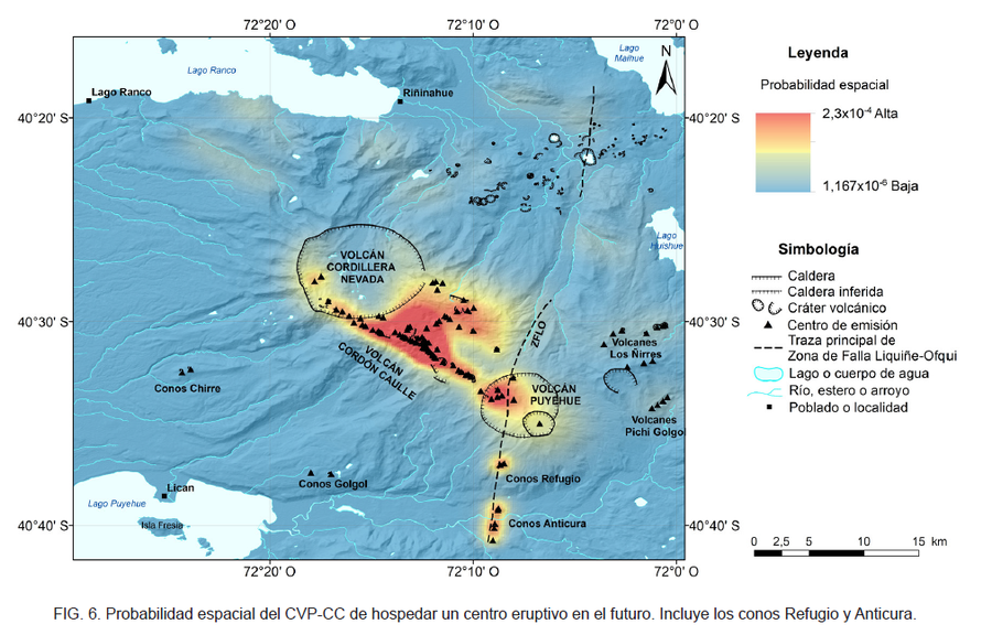
Probabilidad espacial del CVP-CC de hospedar un centro eruptivo en el futuro
Spatial probability of the CVP-CC of hosting an eruptive center in the future
Puyehue-Cordon Caulle, Chile, 2020
Figure 6 in: Toloza, V., Jorquera, C., Mella, M., Gho, R. (2020). Peligros del Complejo Volcánico Puyehue-Cordón Caulle, regiones de Los Ríos y Los Lagos. Servicio Nacional de Geología y Minería, Carta Geológica de Chile, Serie Geología Ambiental 36, 63 p., 1 mapa escala 1:75.000. Santiago.
This map was produced by an official agency, but may not be the most recent, most complete, or main operational map.
For the current operational hazard map, please consult the proper institutional authorities.
Map Set
Toloza, V., Jorquera, C., Mella, M., Gho, R. (2020). Peligros del Complejo Volcánico Puyehue-Cordón Caulle, regiones de Los Ríos y Los Lagos. Servicio Nacional de Geología y Minería, Carta Geológica de Chile, Serie Geología Ambiental 36, 63 p., 1 mapa escala 1:75.000. Santiago.
http://tienda.sernageomin.cl/TiendaVirtual2/ProductDetail.aspx?pid=2967
Other Maps In Set:
- Peligros del Complejo Volcánico Puyehue-Cordón Caulle, regiones de Los Ríos y Los Lagos
- Zonificación de peligro por flujos de lavas en el volcán Puyehue, y los conos Refugio y Anticura
- Zonificación de peligro por flujos de lava en el volcán Cordón Caulle
- Zonificación de peligro por corrientes piroclásticas densas en el volcán Puyehue
- Zonificación de peligro por corrientes piroclásticas densas en el volcán Cordón Caulle
- Zonificación de peligro por lahares primarios en el volcán Puyehue
- Zonificación de peligro por lahares secundarios en el volcán Puyehue
- Zonificación de peligro por lahares primarios en el volcán Cordón Caulle
- Zonificación de peligro por lahares secundarios en el volcán Cordón Caulle
- Zonificación de peligro por piroclastos balísticos en el Complejo Volcánico Puyehue-Cordón Caulle