Spatial probability analysis considering: (A) volcanic events, and (B) volcanic events (80%) and structural data (20%)
Central Volcanic Zone of the Andes (Chile and Argentina), Argentina, Bolivia, Chile, Chile-Argentina, Chile-Bolivia, 2022
Figure 11 in: Bertin, D., Lindsay, J.M., Cronin, S.J., de Silva, S.L., Connor, C.B., Caffe, P.J., Grosse, P., Báez, W., Bustos, E., & Constantinescu, R. (2022). Probabilistic Volcanic Hazard Assessment of the 22.5–28° S Segment of the Central Volcanic Zone of the Andes. Frontiers in Earth Science, 10. https://doi.org/10.3389/feart.2022.875439
This hazard map is the result of scientific research and was published in academic literature.
It is presented here to serve as an example of the map type or the map-making methodology. It is NOT the official, operational map. For the current operational hazard map, please consult the proper institutional authorities.
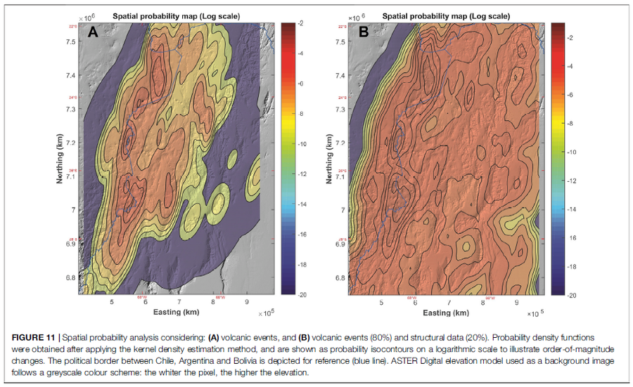
Click on image for full-size map. If link seems broken, try the archived version.
Map Set
Bertin, D., Lindsay, J.M., Cronin, S.J., de Silva, S.L., Connor, C.B., Caffe, P.J., Grosse, P., Báez, W., Bustos, E., & Constantinescu, R. (2022). Probabilistic Volcanic Hazard Assessment of the 22.5–28° S Segment of the Central Volcanic Zone of the Andes. Frontiers in Earth Science, 10. https://doi.org/10.3389/feart.2022.875439
https://doi.org/10.3389/feart.2022.875439
Other Maps In Set:
- Spatial probability maps of volcanic activity for our study area
- Spatio-temporal probability maps of future volcanic activity for our study area at different forecasting time intervals
- Probabilistic volcanic hazard maps for the Central Volcanic Zone of Chile and Argentina (∼22.5–28°S), obtained after empirical, semi-empirical or analytical modeling
- Integrated quantitative volcanic hazard map, constructed by adding each probability map (Figures 6A–E), weighted evenly
Map Data
Map ID | 3942 |
---|---|
Hazard Process(es) | Vent-opening hazards |
Hazard Zone Presentation | Single hazard: A single hazard process is represented on a series of small map panels of similar sizes |
Temporal Scale | Background, or long-term, map |
Spatial Scale | Regional |
Publication Format | Figure in a journal article |
Zonation Method(s) | Probabilistic modeling |
Zonation Model(s) | MatHaz (Bertin et al. 2019); Unnamed KDE vent-opening model [Connor & Connor (2009)] (Connor & Connor 2009) |
Scenario(s) Considered | Source location or direction |
Hazard Zone Label(s) | Numeric probability |
Probability Definition(s) | Numeric probability |
Purpose | Scientific interest: Intended for scientific research and general scientific interest; usually published in academic journals |
Audience | Scientists (usually in scientific publication) |
Language(s) | English |
Basemap(s) | Hillshade |
Basemap overlay(s) | |
Diemsionality | Planimetric (2D or map) view |
Color Scheme | Rainbow |