
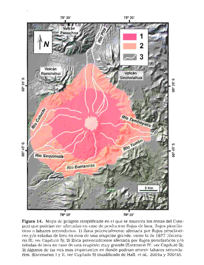
Mapa de peligros simplificado en el que se muestra las zonas del Cotopaxi que podrían ser afectadas en caso de producirse lujos de lava
Simplified hazard map showing the areas of Cotopaxi that could be affected in the event of lava flows
Cotopaxi, Ecuador, 2005
Figure 14 in: Andrade, D., Hall, M., Mothes, P., Troncoso, L., Eissen, J.-P., Samaniego, P., Egred, J., Ramón, P., Rivero, D., and Yepes, H. (2005). Los peligros volcánicos asociados con el Cotopaxi. Instituto Geofísico Escuela Politécnica Nacional (IG-EPN), Institut de Recherche pour la Développement (IRD), Corporación Editora Nacional, Quito. https://horizon.documentation.ird.fr/exl-doc/pleins_textes/divers20-05/010036189.pdf
This map was produced by an official agency, but is NOT the most recent, most complete, or main operational map.
For the current operational hazard map, please consult the proper institutional authorities.
Click on thumbnail for full-size map. We do not have copyright permission to display the full-size image. If you are the copyright holder and wish to provide copyright, please contact us at admin@volcanichazardmaps.org.
Map Set
Andrade, D., Hall, M., Mothes, P., Troncoso, L., Eissen, J.-P., Samaniego, P., Egred, J., Ramón, P., Rivero, D., and Yepes, H. (2005). Los peligros volcánicos asociados con el Cotopaxi. Instituto Geofísico Escuela Politécnica Nacional (IG-EPN), Institut de Recherche pour la Développement (IRD), Corporación Editora Nacional, Quito. https://horizon.documentation.ird.fr/exl-doc/pleins_textes/divers20-05/010036189.pdf
https://horizon.documentation.ird.fr/exl-doc/pleins_textes/divers20-05/010036189.pdf
Other Maps In Set:
- Mapa regional de la zona ubicada al norte del Cotopaxi que seria más afectada en caso de una erupción del volcán
- Mapa regional de la zona ubicada al sur del Cotopaxi que seria más afectada en caso de una erupción del volcán
- Maps de peligros simplificado en el que se muestra las zonas del Cotopaxi que podrian ser afectadas por lluvias de ceniza y piroclasios, lahares primarios y avalanchas de escombros
Simplified, modified, or derived from:
- Mapa Regional de Peligros Volcánicos Potenciales del Volcán Cotopaxi - Zona Sur
- Mapa Regional de Peligros Volcánicos Potenciales del Volcán Cotopaxi - Zona Norte