
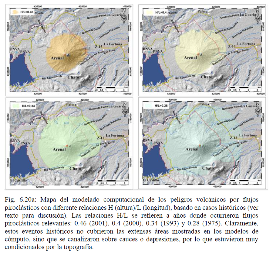
Mapa del modelado computacional de los peligros volcánicos por flujos piroclásticos con diferente relaciones H (altura)/L (longitud), basado en casos históricos
Map of computational modeling of volcanic hazards due to pyroclastic flows with different H (height)/L (length) ratios, based on historical cases
Arenal, Costa Rica, 2023
Figure 6.20a in: Alvarado, G.E., Brenes-André, F., Núñez, D., Borbón, J., Ramírez, M.A., Alpízar, Y., Núñez, S., Sibaja, J.P., Esquivel, L. (2023). Actualización del Análisis del Peligro Volcánico del Arenal, Costa Rica. Instituto Costarricense de Electricidad (ICE). Mayo 2023.
This map was produced by an official agency, but may not be the most recent, most complete, or main operational map.
For the current operational hazard map, please consult the proper institutional authorities.
Click on image for full-size map.
Map Set
Alvarado, G.E., Brenes-André, F., Núñez, D., Borbón, J., Ramírez, M.A., Alpízar, Y., Núñez, S., Sibaja, J.P., Esquivel, L. (2023). Actualización del Análisis del Peligro Volcánico del Arenal, Costa Rica. Instituto Costarricense de Electricidad (ICE). Mayo 2023.
http://dx.doi.org/10.13140/RG.2.2.28921.65120
Other Maps In Set:
- Planta Hidroeléctrica Arenal. Amenaza Volcánica Presa Sangregado.
- Planta Hidroeléctrica Arenal. Amenaza por Caída de Ceniza Volcánica Erupcioón Vulcaniana a Corto Plaza.
- Planta Hidroeléctrica Arenal. Amenaza por Caída de Ceniza Volcánica Erupción Pliniana-Subpliniana a Largo Plazo.
- Planta Hidroeléctrica Arenal. Amenaza por Lahares Presa Sangregado. Volumen: 300.000 m3
- Patrón generado con la MC39, viento a las 3:00 p.m., columna de 16 km
- Patrón de caída generado a partir de la MC39 con el viento presente a las 11:00 a.m. y una columna de 16 km
- Patrón de caída generado a partir de la granulometría de la muestra MH8, con una columna de 16 km y el viento presente a las 11:00 a.m.
- Patrón de caída generado con una columna de 16 km y el viento presente a las 11:00 a.m., a partir de la granulometría de la muestra MH10
- Posible afectación de puentes por peligro volcánico a corto plazo
- Posible afectación de puentes a corto y largo plazo
- Relación entre el peligro volcánico y la vulnerabilidad de las estructuras
- Arriba, proyección poblacional y crecimiento urbano de La Fortuna 2011-2030, mientras que abajo se presenta y su exposición ante los peligros volcánicos
- Mapa de restricción de uso del suelo, volcán Arenal
- Mapa de peligros volcánicos por flujos piroclásticos con diferente relación H/L basado en casos hipotéticos prehistóricos (particularmente H/L 0.15), que se puedan repetir en el futuro
- Peligro por caída de proyectiles balísticos
- Mapa de peligros con base en el modelado de la extensión de los lahares
- Rutas de evacuación estudiadas a lo largo del volcán Arenal.
- Propuesta para la división del círculo de 5.5 km de radio en subzonas de acuerdo con la peligrosidad a corto plazo, discutida en el texto (Soto, 2004)
- Áreas de Peligro por Coladas de Lava
- Peligro por caída de proyectiles balísticos
- Planta Hidroeléctrica Arenal. Amenaza por Caída de Ceniza Volcánica Erupción Estromboliana Violenta a Mediano Plazo.
- Planta Hidroeléctrica Arenal. Amenaza por Lahares Presa Sangregado. Volumen: 100.000 m3
- Planta Hidroeléctrica Arenal. Amenaza por Lahares Presa Sangregado.
- Dispersión del SO2 por la emisión del volcán Arenal
- Dispersión de las PTS por la emisión del volcán Arenal
- Concentración diaria de SO2 por deposición húmeda debido a las emisiones del volcán Arenal
- Concentración diaria de SO2 por deposición húmeda debido a las emisiones del volcán Arenal
- Concentración diaria de PTS por deposición húmeda debido a las emisiones del volcán Arenal
- Concentración diaria de PTS por deposición seca debido a las emisiones del volcán Arenal