
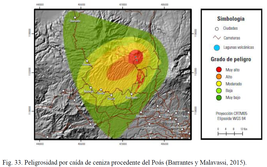
Peligrosidad por caída de ceniza procedente del Poás
Danger due to ash fall from Poás
Poás, Costa Rica, 2020
Figure 33 in: Alvarado, G.E., Esquivel, L., Sánchez, B.E., & Alfaro, J.C. (2020). Actualización del Peligro Volcánico del Poás, Costa Rica. Comisión Nacional de Prevención de Riesgos y Atención de Emergencias (CNE). Febrero 2020. (Reproduced from: Barrantes & Malavassi 2015).
This map was produced by an official agency, but may not be the most recent, most complete, or main operational map.
For the current operational hazard map, please consult the proper institutional authorities.
Click on image for full-size map.
Map Set
Alvarado, G.E., Esquivel, L., Sánchez, B.E., & Alfaro, J.C. (2020). Actualización del Peligro Volcánico del Poás, Costa Rica. Comisión Nacional de Prevención de Riesgos y Atención de Emergencias (CNE). Febrero 2020.
https://www.researchgate.net/publication/351781086_ACTUALIZACION_DEL_PELIGRO_VOLCANICO_DEL_POAS_COSTA_RICA
Other Maps In Set:
- Actualización Peligro Volcánico, Poás. Amenaza por Gases y Lluvia Ácida
- Actualización Peligro Volcánico, Poás. Amenaza por Piroclástos.
- Simulación de depósitos de tefra hecha con Ash3d para una erupción estromboliana menor de duración corta
- Plantas Hidroeléctricas Toro 1, 2, y 3: Actualizción de la Amenaza Volcánica del Poás. Amenaza por Caída de Ceniza Erupción Estromboliana
- Simulaciones de depósitos de tefra hecha con Ash3d.
- Simulaciones de depósitos de tefra hecha con Ash3d
- Actualización Peligro Volcánico, Poás. Amenaza por Balistica.
- Plantas Hidroeléctricas Toro 1, 2, y 3: Actualizción de la Amenaza Volcánica del Poás. Amenaza por Lahares (varios escenarios)
- Plantas Hidroeléctricas Toro 1, 2, y 3: Actualizción de la Amenaza Volcánica del Poás. Amenaza por Lahares