← Back to Search Results

Accumulated ash fallout probability and mass

Irazú, Costa Rica, 2018

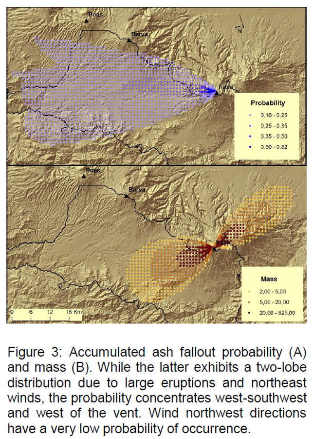
Figure 3 in: Barrantes, G., Núñez, S., & Malavassi, E. (2018). Ash fallout hazard from Irazú volcano, Costa Rica. Revista Geográfica de Chile Terra Australis, 54(1), 13-25. https://doi.org/10.23854/07199562.2018541Barrantes13


This hazard map is the result of scientific research and was published in academic literature. It is presented here to serve as an example of the map type or the map-making methodology. It is NOT the official, operational map. For the current operational hazard map, please consult the proper institutional authorities.


Click on image for full-size map.

Map Set

Barrantes, G., Núñez, S., & Malavassi, E. (2018). Ash fallout hazard from Irazú volcano, Costa Rica. Revista Geográfica de Chile Terra Australis, 54(1), 13-25. https://doi.org/10.23854/07199562.2018541Barrantes13
https://doi.org/10.23854/07199562.2018541Barrantes13

Other Maps In Set:

Map Data

Map ID4034
Hazard Process(es)Tephra fall
Hazard Zone PresentationSingle hazard: A single hazard process is represented on a series of small map panels of similar sizes
Temporal ScaleBackground, or long-term, map
Spatial ScaleVolcano and surrounding area
Publication FormatFigure in a journal article
Zonation Method(s)Probabilistic modeling
Zonation Model(s)Unnamed tephra diffusion and fall model [Suzuki (1985)] (Suzuki 1985)
Scenario(s) ConsideredSeason or weather; Size, VEI, or intensity
Hazard Zone Label(s)Estimated value or Hazard Impact Metric; Numeric probability
Probability Definition(s)Numeric probability
PurposeScientific interest: Intended for scientific research and general scientific interest; usually published in academic journals
AudienceScientists (usually in scientific publication)
Language(s)English
Basemap(s)Hillshade
Basemap overlay(s)Street map
DiemsionalityPlanimetric (2D or map) view
Color SchemeDark to Light (color)
Go to Global Volcanism Program page for Irazú →