
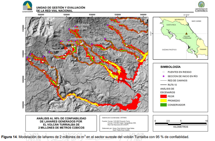
Análisis al 95% de Confiabilidad de Lahares Generados por el Volcán Turrialba de 2 Millones de Metros Cúbicos
95% Reliability Analysis of Lahars Generated by the Turrialba Volcano of 2 Million Cubic Meters
Turrialba, Costa Rica, 2015
Figure 14 in: Ruiz, P., Vega, P. & Barrantes, R. (2015). Modelación de lahares generados por el volcán Turrialba y su posible afectación a la red vial nacional. Laboratorio Nacional de Materiales y Modelos Estructurales. Universidad de Costa Rica 42 pp.
This map was produced by an official agency, but is NOT the most recent, most complete, or main operational map.
For the current operational hazard map, please consult the proper institutional authorities.
Click on thumbnail for full-size map. We do not have copyright permission to display the full-size image. If you are the copyright holder and wish to provide copyright, please contact us at admin@volcanichazardmaps.org.
Map Set
Ruiz, P., Vega, P. & Barrantes, R. (2015). Modelación de lahares generados por el volcán Turrialba y su posible afectación a la red vial nacional. Laboratorio Nacional de Materiales y Modelos Estructurales. Universidad de Costa Rica 42 pp.
https://www.lanamme.ucr.ac.cr/repositorio/bitstream/handle/50625112500/42/LM-PI-UGERVN-11-2015.pdf?sequence=1&isAllowed=y
Other Maps In Set:
- Resultado de modelación con LAHARZ para el volcán Irazú
- Modelación de Lahares Generados por el Volcán Turrialba para 2, 3, y 5 Millones de Metros Cúbicos
- Análisis al 95% de Confiabilidad de Lahares Generados por el Volcán Turrialba de 2 Millones de Metros Cúbicos
- Análisis al 95% de Confiabilidad de Lahares Generados por el Volcán Turrialba de 2 Millones de Metros Cúbicos
- Análisis al 95% de Confiabilidad de Lahares Generados por el Volcán Turrialba de 2 Millones de Metros Cúbicos
- Modelación de Lahares Generados por el Volcán Turrialba para 1, 2, y 3 Millones de Metros Cúbicos