
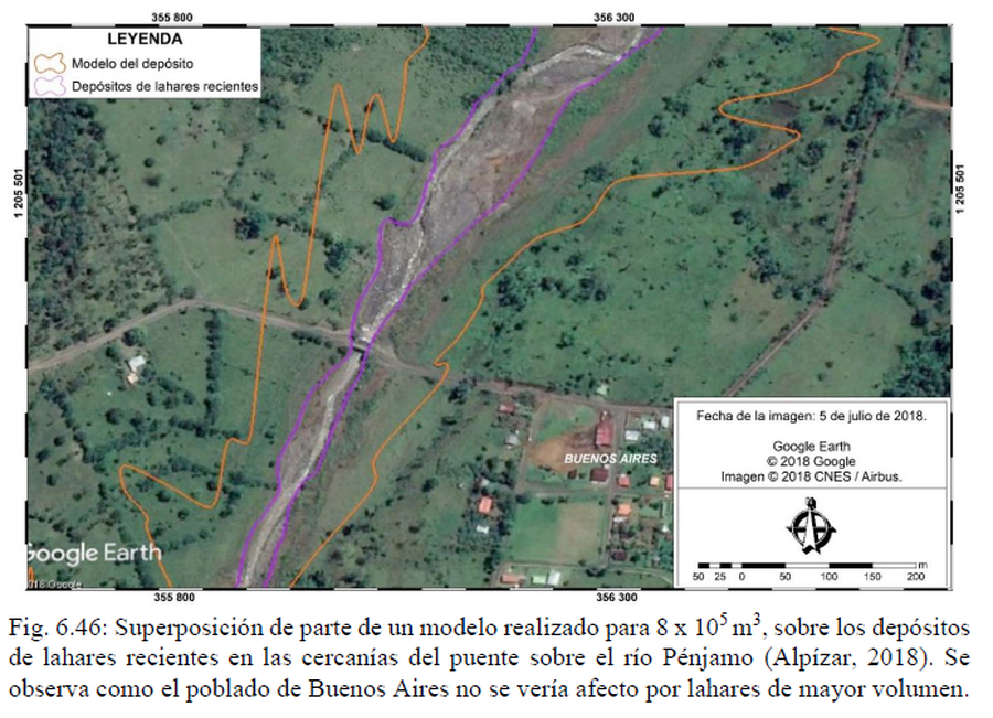
Superposición de parte de un modelo realizado para 8 x 10^5 m3, sobre los depósitos de lahares recientes en las cercanías del puente sobre el río Pénjamo
Superposition of part of a model made for 8 x 10^5 m3, on the recent lahar deposits in the vicinity of the bridge over the Pénjamo River
Rincón de la Vieja, Costa Rica, 2022
Figure 6.46 in: Alvarado, G.E., Brenes-André, J., Venegas, L., Alpízar, Y., Núñez, S., Sánchez, M., Abarca, K., Abarca, J., Báez, W.A., Sibaja, J.P., Esquivel, L., & Arcia, T. (2022). Análisis del Peligro Volcánico del Rincón de la Vieja, Costa Rica. Instituto Costarricense de Electricidad (ICE). Setiembre 2022. (Modified from: Alpízar, 2018)
This map was produced by an official agency, but may not be the most recent, most complete, or main operational map.
For the current operational hazard map, please consult the proper institutional authorities.
Click on image for full-size map.
Map Set
Alvarado, G.E., Brenes-André, J., Venegas, L., Alpízar, Y., Núñez, S., Sánchez, M., Abarca, K., Abarca, J., Báez, W.A., Sibaja, J.P., Esquivel, L., & Arcia, T. (2022). Análisis del Peligro Volcánico del Rincón de la Vieja, Costa Rica. Instituto Costarricense de Electricidad (ICE). Setiembre 2022.
http://dx.doi.org/10.13140/RG.2.2.27064.21761
Other Maps In Set:
- Cálculo por medio del ASH3D de la caída de ceniza de una columna eruptiva de 3 km de altura sobre el cráter del Rincón de la Vieja, según los vientos presentes en el área el 14 mayo 2022
- Pronóstico de la pluma de cenizas, gases y aerosoles que dispersó inicialmente hacia el N y NW generando caída de ceniza sobre los pueblos de la zona, propiamente en las localidades de Dos Ríos y Las Bromelias (Upala) y, después, al occidente
- El modelo de dispersión de SO2 para la misma erupción
- Volcán Rincón de la Vieja: Niveles de Amenaza Volcánica en General
- Mapa de peligros volcánicos Rincón de la Vieja
- Mapa Preliminar de Peligros Volcánicos Volcán Rincón de la Vieja
- Concentración anual de PTS debido a las emisiones del volcán Rincón de la Vieja
- Concentración anual de SO2 debido a las emisiones del volcán Rincón de la Vieja
- Concentración anual de PTS por deposición húmeda debido a las emisiones del volcán Rincón de la Vieja
- Concentración anual de PTS por deposición seca debido a las emisiones del volcán Rincón de la Vieja
- Concentración anual de SO2 por deposición húmeda debido a las emisiones del volcán Rincón de la Vieja
- Mapa de peligrosidad por PTS y SO2 en el aire debido a las emisiones del volcán Rincón de la Vieja
- Mapa de peligrosidad por coladas de lava
- Comparación Entre Flujos Piroclásticos Modelados y Cartografiados
- Los mapas corresponden a la moda de -4.8 phi (superior izquierda), -1.75 phi (superior derecha) generados con el patrón de vientos a las 11 a.m.
- Suma de los 4 mapas generados vía FALL3D con clastos de tamaño variable escogido al azar, utilizando las distribuciones de Weibull
- Mapa de caída de ceniza generado vía FALL3D con la granulometría (en enteros de phi) de muestra recolectada en el campo
- Ampliación del área calculada a partir de la moda de -4 phi, que destaca la proporción relativa de las 3 áreas de peligrosidad: roja, amarilla y verde
- Sobreposición del patrón de caída para las 11 a. m. con la capa de los aeropuertos locales
- Amenaza por Caída de Proyectiles Balísticos
- Mapa de peligrosidad por lluvia ácida debido a las emisiones del volcán Rincón de la Vieja
- Modelo de Lahares para Diferentes Volumenes de Flujo Según Frecuencia de Ocurrencia
- Mapa de detalle de un posible lahar de 100 000 m3 (arriba) y 1 500 000 m3 (abajo) bajando por la quebrada “Sin Nombre”
- Mapa de detalle de las obras y de un posible lahar de 100 000 m3 (arriba) y 1 500 000 m3 (abajo) bajando por la quebrada Gata
- Mapa de detalle de las obras y de un posible lahar de 100 000 m3 (arriba) y 1 500 000 m3 (abajo) bajando por la quebrada Pacayal
- Mapa de detalle de las obras y de un posible lahar de 100 000 m3 (arriba) y 1 500 000 m3 (abajo) bajando por el río Salitral
- Modelo de Afectación por Lahares para el Sector Norte del Volcán Rincón de la Vieja
- Modelo de Afectación por Lahares de con 95% de Confiabilidad para 2.1 x 10^6 m3
- Comunidades de Argelia, Buenos Aires, Dos Ríos, El Gavilán y Manzanares: Cobertura y uso de suelo 2021 y escenario de afectación por frecuencia de lahares
- Detalle de afectación por los lahares en los sectores productivos y de vivienda
- Uso del suelo (2021) y escenario de peligro por caída de ceniza en las comunidades de Argenlia, Buenos Aires, Dos Ríos, El Gavilán y Manzanares
- Areas de Peligro Flanco Norte, Volcán Rincón de la Vieja
- Mapa de Amenaza Volcánica, Volcán Rincón de la Vieja