
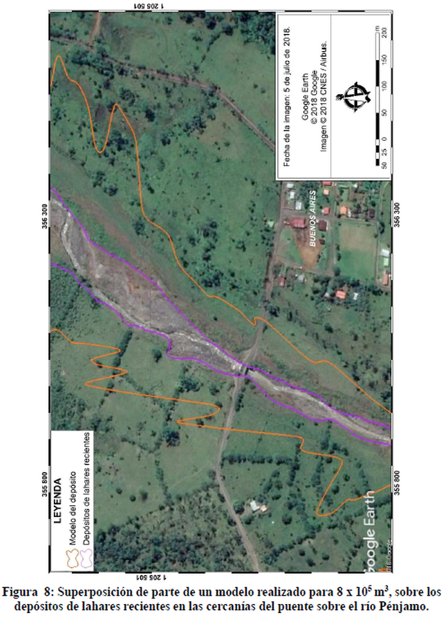
Superposición de Parte de un Modelo Realizado para 8 x 10^5 m3, Sobre los Depósitos de Lahares Recientes en las Cercanías del Puente Sobre el Río Pénjamo
Superposition of Part of a Model mMade for 8 x 10^5 m3, on the Recent Lahar Deposits in the Vicinity of the Bridge Over the Pénjamo River
Rincón de la Vieja, Costa Rica, 2018
Figure 8 in: Alpízar, Y. (2018). Mapa Preliminar de Peligros Volcánicos para el Volcán Rincón de la Vieja (Costa Rica): Descripción de un Escenario de Afectación por Lahares. Ciudad Universitaria Rodrigo Facio, Costa Rica. 160 p.
This hazard map is the result of scientific research and was published in academic literature.
It is presented here to serve as an example of the map type or the map-making methodology. It is NOT the official, operational map. For the current operational hazard map, please consult the proper institutional authorities.
Click on image for full-size map.
Map Set
Alpízar, Y. (2018). Mapa Preliminar de Peligros Volcánicos para el Volcán Rincón de la Vieja (Costa Rica): Descripción de un Escenario de Afectación por Lahares. Ciudad Universitaria Rodrigo Facio, Costa Rica. 160 p.
http://www.kerwa.ucr.ac.cr/handle/10669/80648
Other Maps In Set:
- Modelo de Lahares para Diferentes Volumenes de Flujo
- Modelo de Afectación por Lahares para el Sector Norte del Volcán Rincón de la Vieja
- Modelo de Afectación por Lahares de con 95% de Confiabilidad para 2.1 x 10^6 m3
- Distribución hipotética de los flujos piroclásticos ante un escenario eruptivo como el de 1776 A.C.
- Modelo de Caída de Ceniza Escenario A1
- Modelo de Caída de Ceniza Escenario A2
- Modelo de Caída de Ceniza Escenario A3
- Modelo de Caída de Ceniza Escenario B1
- Modelo de Caída de Ceniza Escenario B2
- Modelo de Caída de Ceniza Escenario B3
- Mapa de Peligro por Caída de Ceniza
- En color morado se muestra la zona de afectación por gases y lluvia ácida propuesta en este trabajo y en naranja, la delimitada por Soto y Martínez (2012)
- Mapa Preliminar de Peligros Volcánicos Volcán Rincón de la Vieja
- Áreas de Peligro Volcánico Volcán Rincón de la Vieja
- Mapa Simplificado de Zonas de Peligro Volcánico y Rutas de Evacuación Sector Norte, Volcán Rincón de la Vieja
- Mapa de peligros volcánicos publicado por Soto et al. (2003b)
- Distribución hipotética de los flujos piroclásticos ante un escenario eruptivo como el de 1776 A.C.