
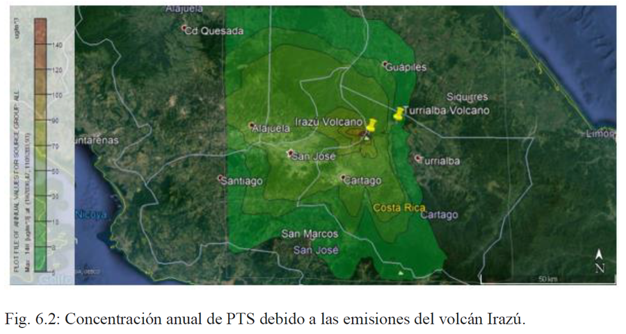
Concentración anual de PTS debido a las emisiones del volcán Irazú
Annual concentration of PTS due to emissions from the Irazú volcano
Irazú, Costa Rica, 2021
Figure 6.2 in: Alvarado, G.E., Campos-Durán, D., Brenes-André, J., Alpízar, Y., Núñez, S., Esquivel, L., Sibaja, J.P. & Fallas, B. (2021). Peligro Volcánico del Irazú, Costa Rica. Comisión Nacional de Prevención de Riesgos y Atención de Emergencias (CNE). Deciembre 2021.
This map was produced by an official agency, but may not be the most recent, most complete, or main operational map.
For the current operational hazard map, please consult the proper institutional authorities.
Click on image for full-size map.
Map Set
Alvarado, G.E., Campos-Durán, D., Brenes-André, J., Alpízar, Y., Núñez, S., Esquivel, L., Sibaja, J.P. & Fallas, B. (2021). Peligro Volcánico del Irazú, Costa Rica. Comisión Nacional de Prevención de Riesgos y Atención de Emergencias (CNE). Deciembre 2021.
http://dx.doi.org/10.13140/RG.2.2.13642.44480
Other Maps In Set:
- Peligrosidad por lluvia ácida y gases
- Plantas de tratamiento de agua del Aya que podrían ser afectadas por la caída de ceniza con una erupción de 8 km de altura
- Multitud de centros educativos en San José, Heredia y Alajuela que se verían efectadas con espesores de 1 mm, e incluso caería ceniza en Cartago, por una erupción de cenizas a las 11 a. m. de 8 km de altura
- Amenaza volcánica por balística
- Principales ríos que podrían ser potencialmente afectados por lahares en un futuro período eruptivo
- Detalle o acercamiento de los principales ríos que podrían ser potencialmente afectados por lahares asociados con el vulcanismo en un futuro período eruptivo en el flanco austral del Irazú
- Detalle de los principales ríos que podrían ser potencialmente afectados por lahares asociados con el vulcanismo en un futuro período eruptivo en el flanco austral del Irazú
- Amenazas volcánicas integradas del Irazú
- Mapa de peligro por caída de cenizas modelado
- Modelado de detalle para un evento lahárico similar al del 9 de diciembre de 1963 pero con las condiciones topográficas y de desarrollo habitacional actual
- Bloque deslizado y bloques con inestabilidad zonificados en según su grado de peligrosidad relativa
- Concentración anual estimada de SO2 debido a las emisiones del volcán Irazú
- Concentración anual estimada de PTS por deposición húmeda debido a las emisiones del volcán Irazú
- Concentración anual estimada de PTS por deposición seca debido a las emisiones del volcán Irazú
- Concentración anual de SO2 estimada por deposición húmeda debido a las emisiones del volcán Irazú