← Back to Search Results

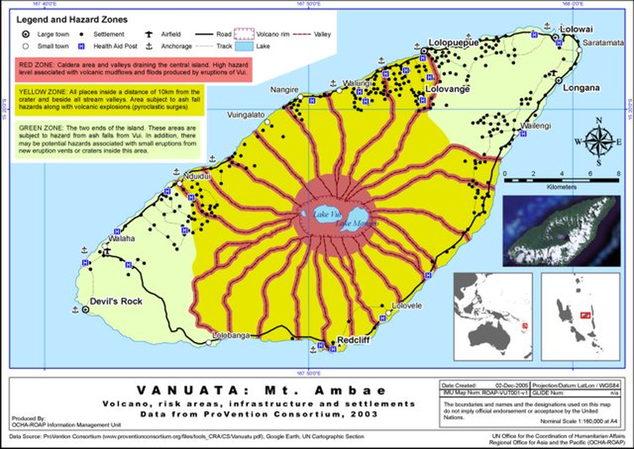
Vanuatu: Mt. Ambae: Volcano, risk areas, infrastructure and settlements data from ProVention Consortium, 2003

Ambae, Vanuatu, 2005

United Nations Office for the Coordination of Humanitarian Affairs Asia and the Pacific (UN OCHA-ROAP) Information Management Unit. (2005). Vanuatu: Mt. Ambae Volcano, risk areas, infrastructure and settlements. UN OCHA-ROAP ROAP-VUT001-v1


This hazard map was created for the situational awareness of an international agency. This map is presented here to serve as an example of this map type. It is NOT the official, operational map. For the current operational hazard map, please consult the proper institutional authorities.


Click on image for full-size map. If link seems broken, try the archived version.

Map Data

Map ID418
Hazard Process(es)Floods or jokulhaups; Lahars; Surges; Tephra fall; Vent-opening hazards
Hazard Zone PresentationHazard level-focused: All or most hazards are combined by hazard level on a main map panel
Temporal ScaleCrisis, or short-term, map (hours to decades)
Spatial ScaleIsland
Publication FormatUnknown format
Zonation Method(s)Derived/simplified from another map
Zonation Model(s)
Scenario(s) ConsideredNo scenarios were discernable from the map
Hazard Zone Label(s)Qualitative relative probability (e.g. high-medium-low)
Probability Definition(s)Qualitative relative probability (e.g. high-medium-low)
PurposeSituational awareness for federal/international government
AudienceInternational relief or aid groups (UN, etc.)
Language(s)English
Basemap(s)Simple or sketch map
Basemap overlay(s)Street map
DiemsionalityPlanimetric (2D or map) view
Color SchemeRed to Green
Go to Global Volcanism Program page for Ambae →