
San Salvador Volcanic Complex - Small-scale PDCs
San Salvador, El Salvador, 2021
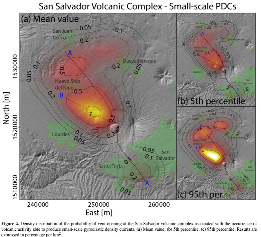
Figure 4 in: Bevilacqua, A., Aravena, A., Neri, A., Gutiérrez, E., Escobar, D., Schliz, M., Aiuppa, A. & Cioni, R. (2021). Thematic vent opening probability maps and hazard assessment of small-scale pyroclastic density currents in the San Salvador volcanic complex (El Salvador) and Nejapa-Chiltepe volcanic complex (Nicaragua). Natural Hazards and Earth System Sciences, 21(5), 1639-1665.
This hazard map is the result of scientific research and was published in academic literature.
It is presented here to serve as an example of the map type or the map-making methodology. It is NOT the official, operational map. For the current operational hazard map, please consult the proper institutional authorities.
Click on image for full-size map.
Map Set
Bevilacqua, A., Aravena, A., Neri, A., Gutiérrez, E., Escobar, D., Schliz, M., Aiuppa, A. & Cioni, R. (2021). Thematic vent opening probability maps and hazard assessment of small-scale pyroclastic density currents in the San Salvador volcanic complex (El Salvador) and Nejapa-Chiltepe volcanic complex (Nicaragua). Natural Hazards and Earth System Sciences, 21(5), 1639-1665.
https://doi.org/10.5194/nhess-21-1639-2021
Other Maps In Set:
- San Salvador Volcanic Complex - Lava emission
- San Salvador Volcanic Complex Non-thematic vent opening probability map and Nejapa-Chiltepe Volcanic Complex Non-thematic vent opening probability map
- Nejapa-Chiltepe Volcanic Complex - Lava emission
- Nejapa-Chiltepe Volcanic Complex - Small-scale PDCs
- San Salvador Volcanic Complex - Small-scale PDCs (Inundation probability)
- Nejapa-Chiltepe Volcanic Complex - Small-scale PDCs (Inundation probability)
- San Salvador Volcanic Complex - Thematic vent opening maps computed using an event counting-based approach