← Back to Search Results

Lahar Hazards for Concepción Volcano, Nicaragua

Concepción, Nicaragua, 2001

Plate 1 in: Vallance, J.W., Schilling, S.P., Devoli, G., & Howell, M.M. (2001). Lahar hazards at Concepción volcano, Nicaragua. U.S. Geological Survey, Open File Report 2001-457, 15 p., 1 plate. https://doi.org/10.3133/ofr01457


This map was produced by an official agency of a foreign government, but is NOT the most recent, most complete, or main operational map. For the current operational hazard map, please consult the proper institutional authorities.


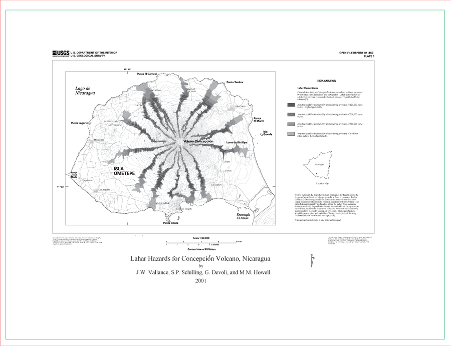
Click on image for full-size map. If link seems broken, try the archived version.

Map Data

Map ID422
Hazard Process(es)Lahars
Hazard Zone PresentationSingle hazard: A single hazard process is represented on a main map panel
Temporal ScaleBackground, or long-term, map
Spatial ScaleVolcano and surrounding area
Publication FormatPoster-style map insert in hazard assessment
Zonation Method(s)Scenario modeling
Zonation Model(s)LAHARZ or modified version (such as PFZ) (Iverson et al. 1998; Schilling 1998; Schilling 2014)
Scenario(s) ConsideredSize, VEI, or intensity
Hazard Zone Label(s)Scenario name
Probability Definition(s)Qualitative relative probability (e.g. high-medium-low)
PurposeMultiple: intended for multiple purposes including general hazard awareness, planning, and crisis management
AudienceMultiple audiences (usually the public, civil authorities, and land-use planners)
Language(s)English
Basemap(s)Contour lines
Basemap overlay(s)Street map
DiemsionalityPlanimetric (2D or map) view
Color SchemeDark to Light (greyscale)
Go to Global Volcanism Program page for Concepción →