
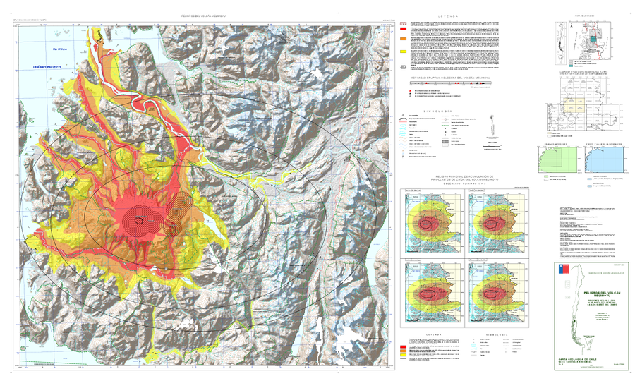
Peligros del Volcán Melimoyu, regiónes de Los Lagos y de Aysén del General Carlos Ibáñez del Campo
Hazards of Melimoyu Volcano, Los Lagos and Aysén regions of General Carlos Ibáñez del Campo
Melimoyu, Chile, 2023
Bono, L., Perales, C., Jorquera, C., Burgos, V. (2023). Peligros del Volcán Melimoyu, región de Aysén del General Carlos Ibáñez del Campo. Servicio Nacional de Geología y Minería, Carta Geológica de Chile, Serie Geología Ambiental 42: 64 p., 1 mapa escala 1:75.000. Santiago
This map was produced by an official agency, but may not be the most recent, most complete, or main operational map.
For the current operational hazard map, please consult the proper institutional authorities.
Click on image for full-size map.
Map Set
Bono, L., Perales, C., Jorquera, C., Burgos, V. (2023). Peligros del Volcán Melimoyu, región de Aysén del General Carlos Ibáñez del Campo. Servicio Nacional de Geología y Minería, Carta Geológica de Chile, Serie Geología Ambiental 42: 64 p., 1 mapa escala 1:75.000. Santiago
https://repositorio.sernageomin.cl/handle/0104/26228
Other Maps In Set:
- Zonificación de peligro por flujos de lava para el Volcán Melimoyu, la Fisura Este y los centros eruptivos menores
- Zonificación de peligro por corrientes de densidad piroclásticas para el Volcán Melimoyu
- Zonificación de peligro por lahares primarios asociados al Volcán Melimoyu
- Zonificación de peligro por lahares secundarios asociados al Volcán Melimoyu
- Zonificación de peligro por piroclastos balísticos para el Volcán Melimoyu, la Fisura Este y los centros eruptivos menores
- Zonificación de peligro asociado a la acumulación de 1 cm de material piroclástico de caída y curvas de isoprobabilidad de acumulación de 10 cm de piroclastos de caída provenientes del Volcán Melimoyu, considerando una erupción pliniana con IEV ≥5, similar a las erupciones MEL-1 y MEL-2