← Back to Search Results

Volcán Sabancaya: Mapas de peligro volcánico

Sabancaya Volcano: Volcanic Hazard Maps

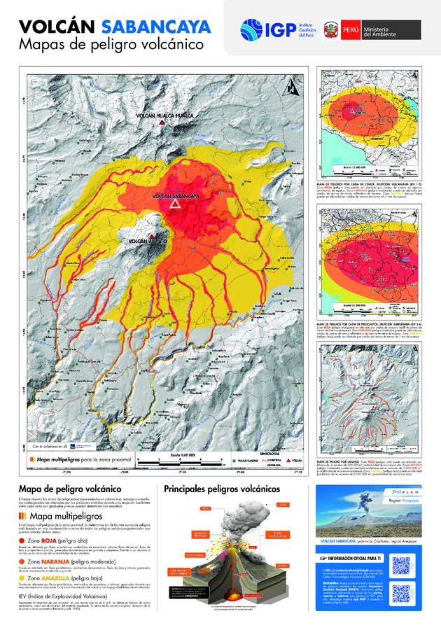
Sabancaya, Peru, 2024

Rivera, M., Cuno, J., Valdivia, D., Del Carpio, J. (2024). Mapa de peligros del volcán Sabancaya. Informe técnico, 2024. Instituto Geofísico del Perú. http://hdl.handle.net/20.500.12816/5634


This map was produced by an official agency, but may not be the most recent, most complete, or main operational map. For the current operational hazard map, please consult the proper institutional authorities.


Click on image for full-size map. If link seems broken, try the archived version.

Map Set

Rivera, M., Cuno, J., Valdivia, D., Del Carpio, J. (2024). Mapa de peligros del volcán Sabancaya. Informe técnico, 2024. Instituto Geofísico del Perú. http://hdl.handle.net/20.500.12816/5634
http://hdl.handle.net/20.500.12816/5634

Map Data

Map ID4312
Hazard Process(es)Ballistics; Debris avalanches; Lahars; Lava flows; PDCs; Tephra fall
Hazard Zone PresentationHazard level- and process-focused: Hazards are both combined by hazard level and separated by hazard process type on a main map and series of insets
Temporal ScaleBackground, or long-term, map
Spatial ScaleVolcano and surrounding area
Publication FormatMap sheet or poster
Zonation Method(s)Geologic history; Probabilistic modeling; Scenario modeling
Zonation Model(s)ASH3D (Schwaiger et al. 2012; Mastin et al. 2013); LAHARZ or modified version (such as PFZ) (Iverson et al. 1998; Schilling 1998; Schilling 2014)
Scenario(s) ConsideredSeason or weather; Size, VEI, or intensity
Hazard Zone Label(s)Qualitative relative probability (e.g. high-medium-low)
Probability Definition(s)Qualitative relative probability (e.g. high-medium-low); Scenarios imply probability
PurposeMultiple: intended for multiple purposes including general hazard awareness, planning, and crisis management
AudienceMultiple audiences (usually the public, civil authorities, and land-use planners)
Language(s)Spanish
Basemap(s)Hillshade
Basemap overlay(s)Contour lines; Street map
DiemsionalityPlanimetric (2D or map) view
Color SchemeRed to Yellow
Volcanic Alert Level System
Go to Global Volcanism Program page for Sabancaya →