
← Back to Search Results

Volcanic Hazard Map of Ol Doinyo Lengaï volcano (Tanzania)

Ol Doinyo Lengai, Tanzania, 2021

Leone, F., Rey, T., Gherardi, M., Defossez, S., Fleurice, P., Cherel, J.-P., Rakoto, M. Candela, T. (2023). Volcanic Hazard Map of Ol Doinyo Lengaï volcano (Tanzania). 10.13140/RG.2.2.30965.35041.


This map may not be the most recent, most complete, or main operational map. For the current operational hazard map, please consult the proper institutional authorities.
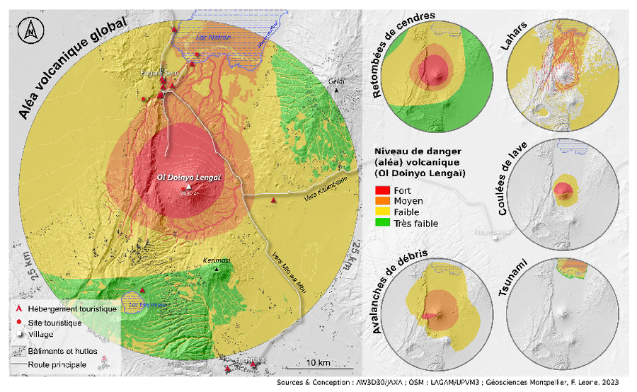

Click on image for full-size map.

Map Data

Map ID4436
Hazard Process(es)Debris avalanches; Lahars; Lava flows; Tephra fall; Tsunami
Hazard Zone PresentationHazard level- and process-focused: Hazards are both combined by hazard level and separated by hazard process type on a main map and series of insets
Temporal ScaleBackground, or long-term, map
Spatial ScaleVolcano and surrounding area
Publication FormatUnknown format
Zonation Method(s)Derived/simplified from another map; Unknown
Zonation Model(s)
Scenario(s) ConsideredSpecific past eruption
Hazard Zone Label(s)Qualitative relative probability (e.g. high-medium-low)
Probability Definition(s)Qualitative relative probability (e.g. high-medium-low)
PurposeScientific interest: Intended for scientific research and general scientific interest; usually published in academic journals
AudienceScientists (usually in scientific publication)
Language(s)French
Basemap(s)Hillshade
Basemap overlay(s)Inhabited areas; Street map
DiemsionalityPlanimetric (2D or map) view
Color SchemeRed to Green
Volcanic Alert Level System
Go to Global Volcanism Program page for Ol Doinyo Lengai →