
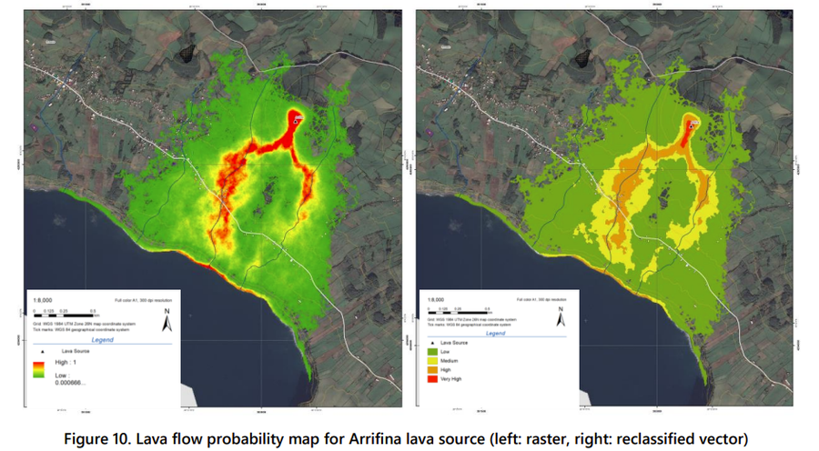
Lava flow probability map for Arrifina lava source (left: raster, right: reclassified vector)
São Jorge, Portugal, 2022
Figure 10 in: Copernicus Emergency Management Service, European Commission – Joint Research Centre. (2022). Volcanic risk assessment in Sao Jorge, Azores Islands (Portugal). Technical Report. Copernicus Emergency Management Service. Risk and Recovery Mapping. Non-standardized products (FLEX) (Lot 1).FWC No: 938352-IPR-2019. EMSN129. Issue: v1.0. https://mapping.emergency.copernicus.eu/activations/EMSN129/
This map was produced by a government agency but may not be the most recent, most complete, or main operational map.
For the current operational hazard map, please consult the proper institutional authorities.
Click on image for full-size map. If link seems broken, try the archived version.
Copernicus Emergency Management Service, European Commission – Joint Research Centre. (2022). Volcanic risk assessment in Sao Jorge, Azores Islands (Portugal). Technical Report. Copernicus Emergency Management Service. Risk and Recovery Mapping. Non-standardized products (FLEX) (Lot 1).FWC No: 938352-IPR-2019. EMSN129. Issue: v1.0. https://mapping.emergency.copernicus.eu/activations/EMSN129/Map Set
https://mapping.emergency.copernicus.eu/activations/EMSN129/
Other Maps In Set: