← Back to Search Results

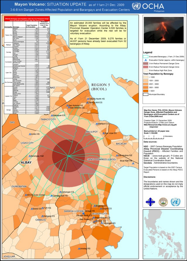
Situation Update as of 11am 21 Dec. 2009, Mayon Volcano Danger Zones, Affected Population and Barangays and Evacuation Centers

Mayon, Philippines, 2009

United Nations Office for the Coordination of Humanitarian Affairs (UN-OCHA) Philippines. (2009). Mayon Volcano Danger Zone Affected Population and Barangays and Evacuation Centers as of 11am 21 Dec 2009.


This hazard map was created for the situational awareness of an international agency. This map is presented here to serve as an example of this map type. It is NOT the official, operational map. For the current operational hazard map, please consult the proper institutional authorities.


Click on image for full-size map. If link seems broken, try the archived version.

Map Data

Map ID448
Hazard Process(es)Access or danger zone
Hazard Zone PresentationHazard level-focused: All or most hazards are combined by hazard level on a main map panel
Temporal ScaleCrisis, or short-term, map (hours to decades)
Spatial ScaleVolcano and surrounding area
Publication FormatUnknown format
Zonation Method(s)Derived/simplified from another map
Zonation Model(s)
Scenario(s) ConsideredNo scenarios were discernable from the map
Hazard Zone Label(s)Access (exclusion, danger, or safe zones)
Probability Definition(s)Qualitative relative probability (e.g. high-medium-low)
PurposeSituational awareness for federal/international government
AudienceInternational relief or aid groups (UN, etc.)
Language(s)English
Basemap(s)Administrative boundaries (e.g. county, park, intl.)
Basemap overlay(s)Population map
DiemsionalityPlanimetric (2D or map) view
Color SchemeRed to Yellow
Go to Global Volcanism Program page for Mayon →