← Back to Search Results

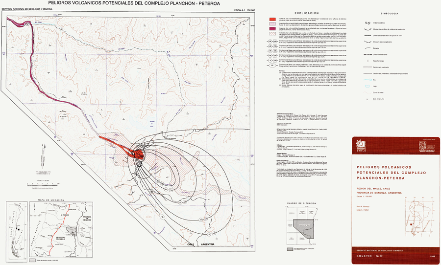
Peligros Volcánicos Potenciales del Complejo Planchón-Peteroa

Potential Volcanic Hazards of the Planchón-Peteroa Complex

Planchón-Peteroa, Chile, 1999

Naranjo, J.A., & Haller, M.J. (1999). Peligros Volcánisoc Potenciales del Complejo Planchon-Peteroa, Región del Maule, Chile - Provincia de Mendoza, Argentina. Servcio Nacional de Geología y Minería (SERNAGEOMIN), Boletín No. 52, 55 p., 2 mapas escala 1:100.000.


This map was produced by an official agency, but may not be the most recent, most complete, or main operational map. For the current operational hazard map, please consult the proper institutional authorities.


Click on image for full-size map. If link seems broken, try the archived version.

Map Data

Map ID476
Hazard Process(es)Debris avalanches (text only); Floods or jokulhaups (text only); Lahars; Lava flows; PDCs; Sedimentation or erosion (text only); Tephra fall
Hazard Zone PresentationGrouped by process (e.g. flowage/fall hazards) on a main map panel
Temporal ScaleBackground, or long-term, map
Spatial ScaleVolcano and surrounding area
Publication FormatMap sheet or poster
Zonation Method(s)Geologic history
Zonation Model(s)
Scenario(s) ConsideredNo scenarios were discernable from the map
Hazard Zone Label(s)Estimated value or Hazard Impact Metric; Hazard process name
Probability Definition(s)Qualitative relative probability (e.g. high-medium-low); Recurrence interval
PurposeMultiple: intended for multiple purposes including general hazard awareness, planning, and crisis management
AudienceMultiple audiences (usually the public, civil authorities, and land-use planners)
Language(s)Spanish
Basemap(s)Contour lines
Basemap overlay(s)Street map
DiemsionalityPlanimetric (2D or map) view
Color SchemeDark to Light (color)
Go to Global Volcanism Program page for Planchón-Peteroa →