← Back to Search Results

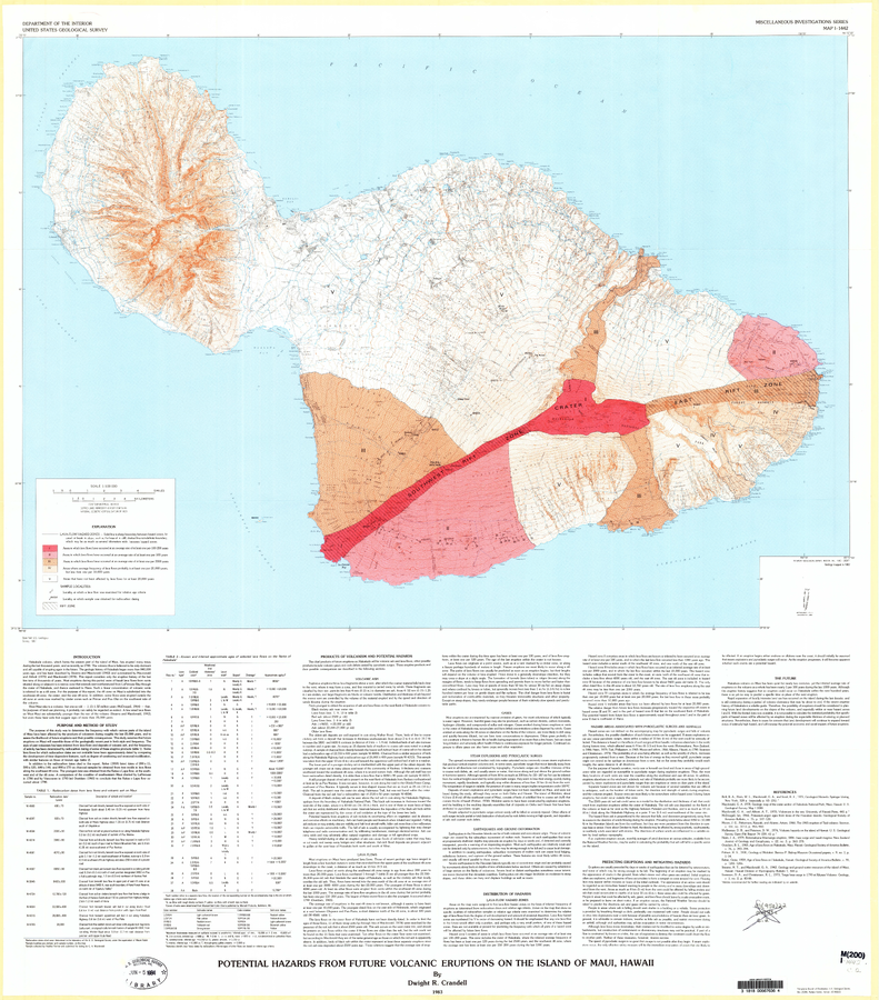
Potential Hazards from Future Volcanic Eruptions of the Island of Maui, Hawaii

Haleakala, United States, 1983

Plate 1 in: Crandell, D.R. (1983). Potential hazards from future volcanic eruptions on the Island of Maui, Hawaii. U.S. Geological Survey, IMAP 1442. https://doi.org/10.3133/i1442


This map was produced by an official agency, but is NOT the most recent, most complete, or main operational map. For the current operational hazard map, please consult the proper institutional authorities.


Click on image for full-size map. If link seems broken, try the archived version.

Map Data

Map ID547
Hazard Process(es)Deformation hazards (text only); Earthquakes (text only); Explosion hazards, unspecific (text only); Gas (text only); Lahars (text only); Lava flows; Lightning (text only); Rockfalls (text only); Surges (text only); Tephra fall (text only)
Hazard Zone PresentationSingle hazard: A single hazard process is represented on a main map panel
Temporal ScaleBackground, or long-term, map
Spatial ScaleIsland
Publication FormatMap sheet or poster
Zonation Method(s)Geologic history
Zonation Model(s)
Scenario(s) ConsideredSpecific past eruption
Hazard Zone Label(s)Hazard process name; Recurrence interval
Probability Definition(s)Recurrence interval
PurposeMultiple: intended for multiple purposes including general hazard awareness, planning, and crisis management
AudienceMultiple audiences (usually the public, civil authorities, and land-use planners)
Language(s)English
Basemap(s)Contour lines
Basemap overlay(s)Street map
DiemsionalityPlanimetric (2D or map) view
Color SchemeRed to Yellow
Go to Global Volcanism Program page for Haleakala →