← Back to Search Results

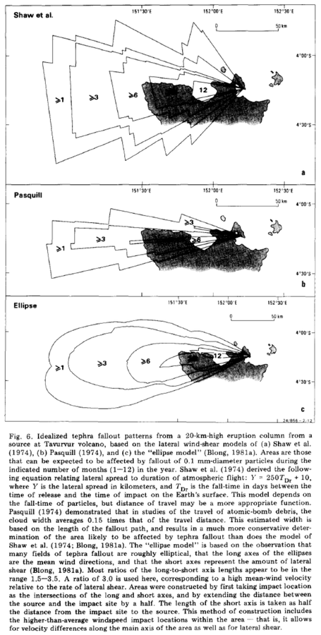
Idealized tephra fallout patterns from a 20-km-high eruption column from a source at Tavurvur volcano

Tavurvur (Rabaul), Papua New Guinea, 1985

Figure 6 in: McKee, C. O., Johnson, R. W., Lowenstein, P. L., Riley, S. J., Blong, R. J., De Saint Ours, P., & Talai, B. (1985). Rabaul caldera, Papua New Guinea: volcanic hazards, surveillance, and eruption contingency planning. Journal of Volcanology and Geothermal Research, 23(3-4), p. 195-237. https://doi.org/10.1016/0377-0273(85)90035-6


This map was produced by an official agency, but is NOT the most recent, most complete, or main operational map. For the current operational hazard map, please consult the proper institutional authorities.


Click on image for full-size map.

Map Set

McKee, C. O., Johnson, R. W., Lowenstein, P. L., Riley, S. J., Blong, R. J., De Saint Ours, P., & Talai, B. (1985). Rabaul caldera, Papua New Guinea: volcanic hazards, surveillance, and eruption contingency planning. Journal of Volcanology and Geothermal Research, 23(3-4), p. 195-237. https://doi.org/10.1016/0377-0273(85)90035-6
https://doi.org/10.1016/0377-0273(85)90035-6

Other Maps In Set:

Map Data

Map ID556
Hazard Process(es)Tephra fall
Hazard Zone PresentationSingle hazard: A single hazard process is represented on a series of small map panels of similar sizes
Temporal ScaleBackground, or long-term, map
Spatial ScaleVolcano and surrounding area
Publication FormatFigure in a journal article
Zonation Method(s)Scenario modeling
Zonation Model(s)Unnamed ellipse tephra model [Blong (1981)] (Blong 1981); Unnamed lateral wind shear tephra model [Pasquill (1974)] (Pasquill 1974); Unnamed lateral wind shear tephra model [Shaw et al. (1974)] (Shaw et al. 1974)
Scenario(s) ConsideredSize, VEI, or intensity
Hazard Zone Label(s)Recurrence interval
Probability Definition(s)Recurrence interval
PurposeScientific interest: Intended for scientific research and general scientific interest; usually published in academic journals
AudienceScientists (usually in scientific publication)
Language(s)English
Basemap(s)Simple or sketch map
Basemap overlay(s)
DiemsionalityPlanimetric (2D or map) view
Color SchemeSymbols and/or lines only
Go to Global Volcanism Program page for Tavurvur (Rabaul) →