← Back to Search Results

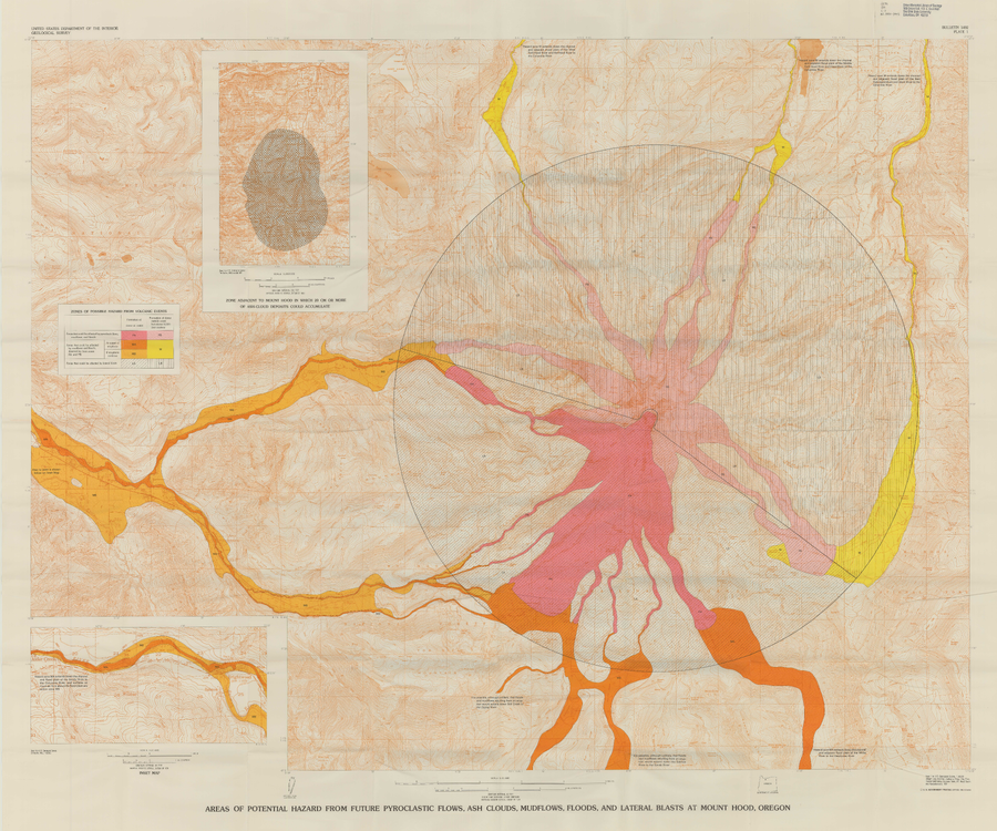
Areas of Potential Hazard from Future Pyroclastic Flows, Ash Clouds, Mudflows, and Lateral Blasts at Mount Hood, Oregon

Hood, United States, 1980

Plate 1 in: Crandell, D.R. (1980). Recent eruptive history of Mount Hood, Oregon, and potential hazards from future eruptions. U.S. Geological Survey, Bulletin 1492, 81 p. https://doi.org/10.3133/b1492


This map was produced by an official agency, but is NOT the most recent, most complete, or main operational map. For the current operational hazard map, please consult the proper institutional authorities.


Click on image for full-size map. If link seems broken, try the archived version.

Map Data

Map ID596
Hazard Process(es)Floods or jokulhaups; Lahars; Lateral or directed blasts; PDCs; Tephra fall
Hazard Zone PresentationGrouped by process (e.g. flowage/fall hazards) on a main map and series of insets
Temporal ScaleBackground, or long-term, map
Spatial ScaleVolcano and surrounding area
Publication FormatPoster-style map insert in hazard assessment
Zonation Method(s)Analog geology; Geologic history
Zonation Model(s)
Scenario(s) ConsideredDuration or timing; Source location or direction
Hazard Zone Label(s)Hazard process name
Probability Definition(s)No probability definition was discernable from the map
PurposeMultiple: intended for multiple purposes including general hazard awareness, planning, and crisis management
AudienceMultiple audiences (usually the public, civil authorities, and land-use planners)
Language(s)English
Basemap(s)Contour lines
Basemap overlay(s)
DiemsionalityPlanimetric (2D or map) view
Color SchemeRed to Yellow
Go to Global Volcanism Program page for Hood →