← Back to Search Results

Flowage Hazard Zones

Glacier Peak, United States, 1982

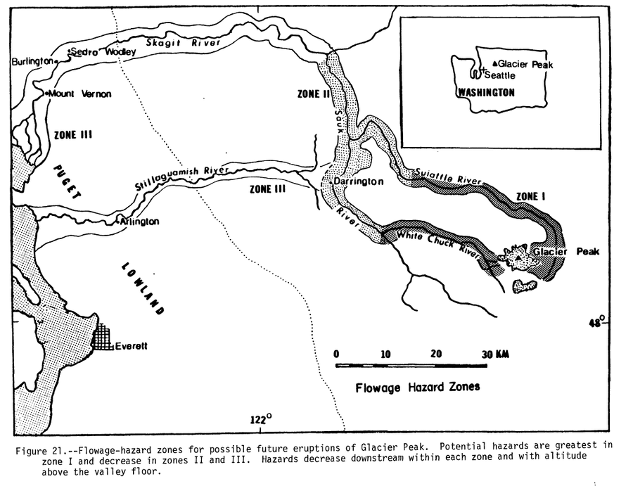
Figure 21 in: Beget, J.E. (1982). Postglacial Volcanic Deposits at Glacier Peak, Washington, and Potential Hazards from Future Eruptions. U.S. Geological Survey, Open-File Report 82-830, 81 p. https://doi.org/10.3133/ofr82830


This map was produced by an official agency, but is NOT the most recent, most complete, or main operational map. For the current operational hazard map, please consult the proper institutional authorities.


Click on image for full-size map. If link seems broken, try the archived version.

Map Set

Beget, J. E. (1982). Postglacial Volcanic Deposits at Glacier Peak, Washington, and Potential Hazards from Future Eruptions. U.S. Geological Survey, Open-File Report 82-830, 81 p. https://doi.org/10.3133/ofr82830
https://doi.org/10.3133/ofr82830

Other Maps In Set:

Map Data

Map ID624
Hazard Process(es)Ash-cloud surges; Flowage hazards; Lahars; PDCs
Hazard Zone PresentationGrouped by process (e.g. flowage/fall hazards) on a main map panel
Temporal ScaleBackground, or long-term, map
Spatial ScaleVolcano and surrounding area
Publication FormatFigure in a hazard assessment or mitigation plan
Zonation Method(s)Geologic history
Zonation Model(s)
Scenario(s) ConsideredNo scenarios were discernable from the map
Hazard Zone Label(s)Qualitative relative probability (e.g. high-medium-low)
Probability Definition(s)Qualitative relative probability (e.g. high-medium-low)
PurposeMultiple: intended for multiple purposes including general hazard awareness, planning, and crisis management
AudienceMultiple audiences (usually the public, civil authorities, and land-use planners)
Language(s)English
Basemap(s)Simple or sketch map
Basemap overlay(s)Inhabited areas
DiemsionalityPlanimetric (2D or map) view
Color SchemeSymbols and/or lines only
Go to Global Volcanism Program page for Glacier Peak →