← Back to Search Results

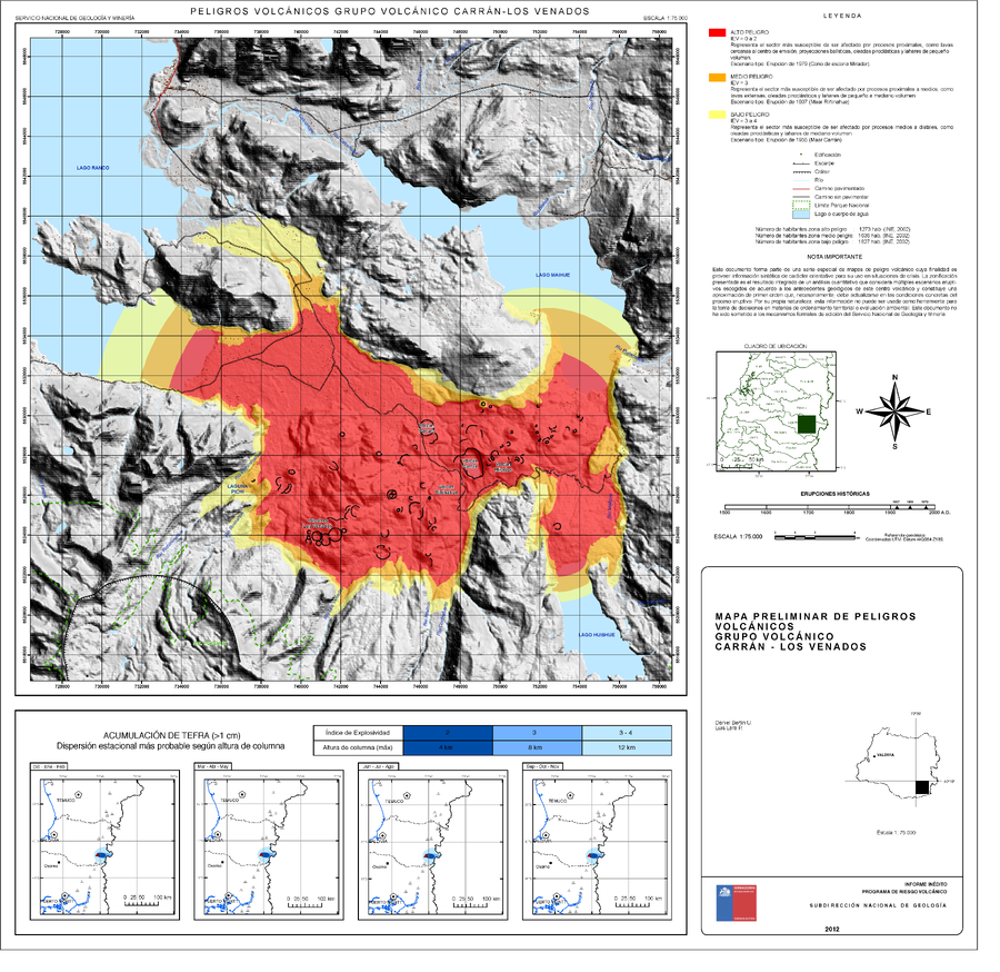
Peligros Volcánicos Grupo Volcánico Carrán-los Venados

Volcanic Hazards Carrán-los Venados Volcanic Group

Carrán-Los Venados, Chile, 2012

Bertin, D. & Lara, L. (2012). Mapa Preliminar De Peligros Volcánicos Grupo Volcánico Carrán - Los Venados. Servicio Nacional de Geología y Minería (SERNAGEOMIN), mapa escala 1:75,000. Santiago.


This map was produced by an official agency, but is NOT the most recent, most complete, or main operational map. For the current operational hazard map, please consult the proper institutional authorities.


Click on image for full-size map. If link seems broken, try the archived version.

Map Data

Map ID726
Hazard Process(es)Ballistics; Lahars; Lava flows; Surges; Tephra fall
Hazard Zone PresentationHazard level-focused: All or most hazards are combined by hazard level on a main map and series of insets
Temporal ScaleBackground, or long-term, map
Spatial ScaleVolcano and surrounding area
Publication FormatMap sheet or poster
Zonation Method(s)Geologic history
Zonation Model(s)
Scenario(s) ConsideredSeason or weather; Size, VEI, or intensity; Specific past eruption
Hazard Zone Label(s)Qualitative relative probability (e.g. high-medium-low); Scenario name
Probability Definition(s)Qualitative relative probability (e.g. high-medium-low); Scenarios imply probability
PurposeCrisis management and response: Intended to be used for managing, responding to, and taking action during an eruption; often includes evacuation routes, access restrictions, actions to take, etc.
AudienceMultiple audiences (usually the public, civil authorities, and land-use planners)
Language(s)Spanish
Basemap(s)Hillshade
Basemap overlay(s)Street map
DiemsionalityPlanimetric (2D or map) view
Color SchemeRed to Yellow
Go to Global Volcanism Program page for Carrán-Los Venados →