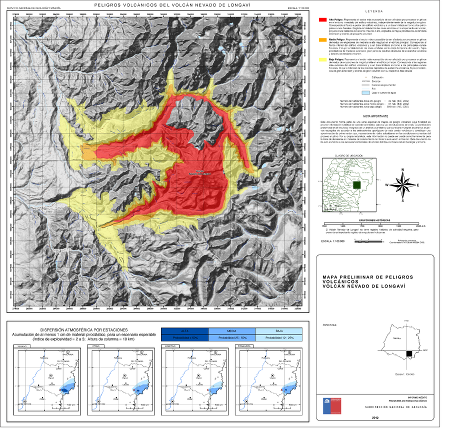
Peligros Volcánicos del Volcán Nevado De Longaví
Volcanic Hazards of Nevado De Longaví Volcano
Nevado de Longavi, Chile, 2012
Kraus, S. (2012). Mapa Preliminar de peligros volcánicos Volcán Nevado de Longaví. Región del Maule. Informe inédito, Subdirección Nacional de Geología, Programa de Riesgo Volcánico, mapa escala 1:100.000. Santiago.
This map was produced by an official agency, but may not be the most recent, most complete, or main operational map.
For the current operational hazard map, please consult the proper institutional authorities.

Click on image for full-size map. If link seems broken, try the archived version.
Map Data
Map ID | 758 |
---|---|
Hazard Process(es) | Ballistics; Debris avalanches; Lahars; Lava flows; PDCs; Tephra fall |
Hazard Zone Presentation | Hazard level-focused: All or most hazards are combined by hazard level on a main map and series of insets |
Temporal Scale | Background, or long-term, map |
Spatial Scale | Volcano and surrounding area |
Publication Format | Map sheet or poster |
Zonation Method(s) | Geologic history; Unknown |
Zonation Model(s) | Unknown tephra model (Unknown reference) |
Scenario(s) Considered | Season or weather; Size, VEI, or intensity |
Hazard Zone Label(s) | Qualitative relative probability (e.g. high-medium-low) |
Probability Definition(s) | Numeric probability; Qualitative relative probability (e.g. high-medium-low) |
Purpose | Crisis management and response: Intended to be used for managing, responding to, and taking action during an eruption; often includes evacuation routes, access restrictions, actions to take, etc. |
Audience | Multiple audiences (usually the public, civil authorities, and land-use planners) |
Language(s) | Spanish |
Basemap(s) | Hillshade |
Basemap overlay(s) | Street map |
Diemsionality | Planimetric (2D or map) view |
Color Scheme | Red to Yellow |